
Topografische Karte Rabbit Island
Interaktive Karte
Klicken Sie auf die Karte, um die Höhe anzuzeigen.
Über diese Karte
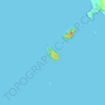
Name: Topografische Karte Rabbit Island, Höhe, Relief.
Ort: Rabbit Island, Waikato, New Zealand (-37.07240 175.92382 -37.06733 175.92890)
Durchschnittliche Höhe: 1 m
Minimale Höhe: -1 m
Maximale Höhe: 56 m
Andere topografische Karten
Klicken Sie auf eine Karte, um ihre Topografie, ihre Höhe und ihr Relief anzuzeigen.
Scotsman Valley
New Zealand > Waikato > Waikato District
Scotsman Valley, Waikato District, Waikato, New Zealand
Durchschnittliche Höhe: 108 m
Wentworth Valley
New Zealand > Waikato > Thames-Coromandel District
Wentworth Valley, Thames-Coromandel District, Waikato, New Zealand
Durchschnittliche Höhe: 114 m
Eureka
New Zealand > Waikato > Waikato District
Eureka, Waikato District, Waikato, 3287, New Zealand
Durchschnittliche Höhe: 49 m
Wyuna Bay
New Zealand > Waikato > Coromandel > Wyuna Bay
Wyuna Bay, Coromandel, Thames Coromandel District, Waikato, 3543, New Zealand
Durchschnittliche Höhe: 12 m
Waipa District
Waipa District, Waikato, New Zealand
Durchschnittliche Höhe: 117 m