
Topografische Karte Brescia
Interaktive Karte
Klicken Sie auf die Karte, um die Höhe anzuzeigen.
Über diese Karte
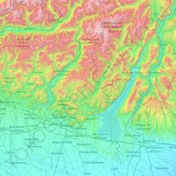
Name: Topografische Karte Brescia, Höhe, Relief.
Ort: Brescia, Lombardy, Italy (45.20425 9.83629 46.35485 10.84268)
Durchschnittliche Höhe: 853 m
Minimale Höhe: 15 m
Maximale Höhe: 3.585 m
Due to the altitude and morphological variety and the presence of large lakes, the province includes all kinds of biomes in Europe: from something similar to the maquis shrubland up to the perennial snow of Adamello (with the largest glacier in the Italian Alps).
Andere topografische Karten
Klicken Sie auf eine Karte, um ihre Topografie, ihre Höhe und ihr Relief anzuzeigen.
Valle Salimbene
Italy > Lombardy > Pavia > Valle Salimbene
Valle Salimbene, Pavia, Lombardy, 27010, Italy
Durchschnittliche Höhe: 67 m
Lake Maggiore
Italy > Lombardy > Castelveccana
Lake Maggiore, Via dei Caduti per la Patria, Cascina Girolo, Castelveccana, Comunità Montana Valli del Verbano, VA, Lombardy, 28823, Italy
Durchschnittliche Höhe: 655 m
Bergamasque Alps and Prealps
Italy > Lombardy > Oltre il Colle
Bergamasque Alps and Prealps, Oltre il Colle, Comunità Montana della Valle Brembana, BG, Lombardy, Italy
Durchschnittliche Höhe: 977 m
Lago di Lei
Lago di Lei, Mottalla - Passo dell'Angeloga, Alpe Mottala, Piuro, Comunità Montana della Valchiavenna, SO, Lombardy, Italy
Durchschnittliche Höhe: 2.318 m