
Topografische Karte Kibawe
Interaktive Karte
Klicken Sie auf die Karte, um die Höhe anzuzeigen.
Über diese Karte
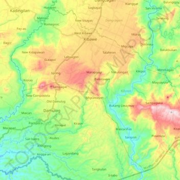
Name: Topografische Karte Kibawe, Höhe, Relief.
Ort: Kibawe, Bukidnon, Northern Mindanao, 8720, Philippines (7.41800 124.89974 7.60196 125.10495)
Durchschnittliche Höhe: 267 m
Minimale Höhe: 47 m
Maximale Höhe: 626 m
Kibawe is a rich land at the center of Mindanao, located in southern Bukidnon. It is bounded in the north by the municipality of Dangcagan, on the south by the municipality of Damulog, on the east by the municipality of Magpet, North Cotabato, and on the west by the municipality of Kadingilan with Muleta River serving as a natural boundary. It has a total land area of 301.43 square kilometres (116.38 sq mi), with an approximate land elevation of 337 metres (1,106 ft) above sea level.
Andere topografische Karten
Klicken Sie auf eine Karte, um ihre Topografie, ihre Höhe und ihr Relief anzuzeigen.
Casisang
Philippines > Bukidnon > Malaybalay
Casisang, Malaybalay, Bukidnon, Northern Mindanao, 8700, Philippines
Durchschnittliche Höhe: 715 m