
Topografische Karte Kettle River
Interaktive Karte
Klicken Sie auf die Karte, um die Höhe anzuzeigen.
Über diese Karte
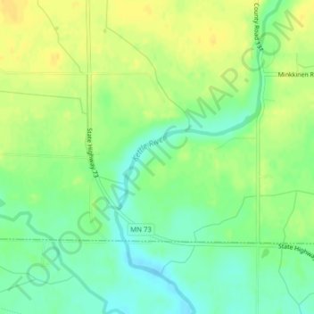
Name: Topografische Karte Kettle River, Höhe, Relief.
Durchschnittliche Höhe: 367 m
Minimale Höhe: 354 m
Maximale Höhe: 379 m
Andere topografische Karten
Klicken Sie auf eine Karte, um ihre Topografie, ihre Höhe und ihr Relief anzuzeigen.
Savage
États-Unis d'Amérique > Minnesota > Scott County > Savage > Savage
Savage, Scott County, Minnesota, 55378, États-Unis d'Amérique
Durchschnittliche Höhe: 251 m
Minneapolis
États-Unis d'Amérique > Minnesota > Hennepin County > Minneapolis
Minneapolis, Hennepin County, Minnesota, 55488, États-Unis d'Amérique
Durchschnittliche Höhe: 271 m
Murray County
États-Unis d'Amérique > Minnesota > Murray County
Murray County, Minnesota, États-Unis d'Amérique
Durchschnittliche Höhe: 485 m
Saint Paul
États-Unis d'Amérique > Minnesota > Ramsey County
Saint Paul, Ramsey County, Minnesota, États-Unis d'Amérique
Durchschnittliche Höhe: 268 m
Tug Lake
États-Unis d'Amérique > Minnesota > Morris
Tug Lake, East 2nd Street, Morris, Stevens County, Minnesota, 56267, États-Unis d'Amérique
Durchschnittliche Höhe: 340 m
Lake Itasca
États-Unis d'Amérique > Minnesota > Lake Itasca
Lake Itasca, Clearwater County, Minnesota, 56480, États-Unis d'Amérique
Durchschnittliche Höhe: 460 m