
Topografische Karte Mount Wellington
Interaktive Karte
Klicken Sie auf die Karte, um die Höhe anzuzeigen.
Über diese Karte
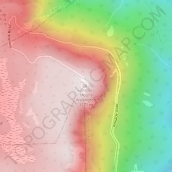
Name: Topografische Karte Mount Wellington, Höhe, Relief.
Ort: Mount Wellington, City of Hobart, Tasmania, Australia (-42.89606 147.23726 -42.89596 147.23736)
Durchschnittliche Höhe: 941 m
Minimale Höhe: 443 m
Maximale Höhe: 1.263 m
"... In many parts the Eucalypti grew to a great size, and composed a noble forest. In some of the dampest ravines, tree-ferns flourished in an extraordinary manner; I saw one which must have been at least twenty feet high to the base of the fronds, and was in girth exactly six feet. The fronds forming the most elegant parasols, produced a gloomy shade, like that of the first hour of the night. The summit of the mountain is broad and flat, and is composed of huge angular masses of naked greenstone. Its elevation is 3,100 feet above the level of the sea. The day was splendidly clear, and we enjoyed a most extensive view; to the north, the country appeared a mass of wooded mountains, of about the same height with that on which we were standing, and with an equally tame outline: to the south the broken land and water, forming many intricate bays, was mapped with clearness before us. ..."
Andere topografische Karten
Klicken Sie auf eine Karte, um ihre Topografie, ihre Höhe und ihr Relief anzuzeigen.
Mount Lloyd
Mount Lloyd, Derwent Valley, Tasmania, 7140, Australia
Durchschnittliche Höhe: 558 m
Curtis Island
Curtis Island, Flinders Council, Tasmania, Australia
Durchschnittliche Höhe: 18 m
Cataract Gorge Reserve
Australia > Tasmania > Launceston
Cataract Gorge Reserve, Launceston, City of Launceston, Tasmania, 7250, Australia
Durchschnittliche Höhe: 125 m
Port Hills
Port Hills, Circular Head, Tasmania, Australia
Durchschnittliche Höhe: 55 m
Dove Lake
Australia > Tasmania > Cradle Mountain
Dove Lake, Cradle Mountain, Kentish, Tasmania, Australia
Durchschnittliche Höhe: 1.060 m
Queenstown
Queenstown, West Coast, Tasmania, 7467, Australia
Durchschnittliche Höhe: 330 m
Legana
Australia > Tasmania > Launceston > Legana
Legana, Launceston, West Tamar, Tasmania, Australia
Durchschnittliche Höhe: 82 m
Launceston
Launceston, City of Launceston, Tasmania, 7250, Australia
Durchschnittliche Höhe: 26 m
Lake Dobson
Lake Dobson, Pandani Grove Nature Walk, Tasmania, Australia
Durchschnittliche Höhe: 1.093 m
King Island Council
King Island Council, Tasmania, Australia
Durchschnittliche Höhe: 14 m
Binalong Bay
Australia > Tasmania > Binalong Bay
Binalong Bay, Tasmania, Australia
Durchschnittliche Höhe: 23 m
Lake McRae
Lake McRae, Overland Track, Tasmania, Australia
Durchschnittliche Höhe: 1.044 m
Lake Margaret
Australia > Tasmania > Lake Margaret
Lake Margaret, Tasmania, Australia
Durchschnittliche Höhe: 436 m
Blythe River
Blythe River, Burnie, Tasmania, 7320, Australia
Durchschnittliche Höhe: 99 m
Hartz Mountains
Hartz Mountains, Tasmania, Australia
Durchschnittliche Höhe: 931 m
Mount Arrowsmith
Mount Arrowsmith, Tasmania, Australia
Durchschnittliche Höhe: 761 m