
Spenden
Rüste dich für dein nächstes Abenteuer:
Als Amazon-Partner verdient diese Website an qualifizierten Käufen, ohne zusätzliche Kosten für Sie.
Topografische Karte Santa Rosa Island
Klicken Sie auf die Karte, um die Höhe anzuzeigen.
Spenden
Rüste dich für dein nächstes Abenteuer:
Als Amazon-Partner verdient diese Website an qualifizierten Käufen, ohne zusätzliche Kosten für Sie.
Über diese Karte
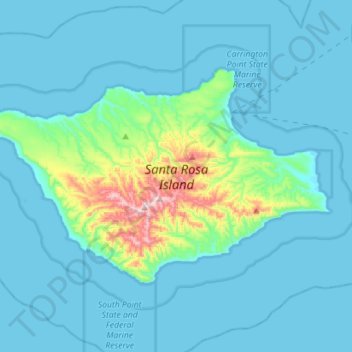
Name: Topografische Karte Santa Rosa Island, Höhe, Relief.
Durchschnittliche Höhe: 51 m
Minimale Höhe: -1 m
Maximale Höhe: 478 m
Spenden
Rüste dich für dein nächstes Abenteuer:
Als Amazon-Partner verdient diese Website an qualifizierten Käufen, ohne zusätzliche Kosten für Sie.
Andere topografische Karten
Klicken Sie auf eine Karte, um ihre Topografie, ihre Höhe und ihr Relief anzuzeigen.
Spenden
Rüste dich für dein nächstes Abenteuer:
Als Amazon-Partner verdient diese Website an qualifizierten Käufen, ohne zusätzliche Kosten für Sie.
Vandenberg Village
United States > California > Santa Barbara County > Lompoc
Durchschnittliche Höhe: 132 m
Spenden
Rüste dich für dein nächstes Abenteuer:
Als Amazon-Partner verdient diese Website an qualifizierten Käufen, ohne zusätzliche Kosten für Sie.
Shoreline Park
United States > California > Santa Barbara County > Santa Barbara
Durchschnittliche Höhe: 21 m
West Beach
United States > California > Santa Barbara County > Santa Barbara
Durchschnittliche Höhe: 8 m
Spenden
Rüste dich für dein nächstes Abenteuer:
Als Amazon-Partner verdient diese Website an qualifizierten Käufen, ohne zusätzliche Kosten für Sie.
Jalama Beach County Park
United States > California > Santa Barbara County > Jalama
Durchschnittliche Höhe: 40 m
North Santa Maria
United States > California > Santa Barbara County > Santa Maria
Durchschnittliche Höhe: 65 m
Spenden
Rüste dich für dein nächstes Abenteuer:
Als Amazon-Partner verdient diese Website an qualifizierten Käufen, ohne zusätzliche Kosten für Sie.
Haskell's Beach
United States > California > Santa Barbara County > Goleta
Durchschnittliche Höhe: 15 m
Spenden
Rüste dich für dein nächstes Abenteuer:
Als Amazon-Partner verdient diese Website an qualifizierten Käufen, ohne zusätzliche Kosten für Sie.
Toro Canyon
United States > California > Santa Barbara County > Toro Canyon
Durchschnittliche Höhe: 83 m
Spenden
Rüste dich für dein nächstes Abenteuer:
Als Amazon-Partner verdient diese Website an qualifizierten Käufen, ohne zusätzliche Kosten für Sie.
Santa Maria
United States > California > Santa Barbara County > Santa Maria
Durchschnittliche Höhe: 185 m
Las Positas Meadows
United States > California > Santa Barbara County > Santa Barbara
Durchschnittliche Höhe: 66 m