
Topografische Karte Elbląg
Interaktive Karte
Klicken Sie auf die Karte, um die Höhe anzuzeigen.
Über diese Karte
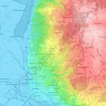
Name: Topografische Karte Elbląg, Höhe, Relief.
Ort: Elbląg, Warmian-Masurian Voivodeship, 82-300, Poland (54.13442 19.35901 54.26326 19.50980)
Durchschnittliche Höhe: 49 m
Minimale Höhe: -6 m
Maximale Höhe: 193 m
The modern city adjoins about half the length of the river between Lake Drużno and Elbląg Bay (Zatoka Elbląska, an arm of the Vistula Lagoon), and spreads out on both banks, though mainly on the eastern side. To the east is the Elbląg Upland (Wysoczyzna Elbląska), a dome pushed up by glacial compression, 390 km2 in diameter and 200 m (656.17 ft) high at its greatest elevation. It gives the appearance of ridges and parkland.