
Topografische Karte Northeastern Manitoulin and the Islands
Interaktive Karte
Klicken Sie auf die Karte, um die Höhe anzuzeigen.
Über diese Karte
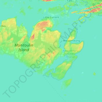
Name: Topografische Karte Northeastern Manitoulin and the Islands, Höhe, Relief.
Durchschnittliche Höhe: 192 m
Minimale Höhe: 169 m
Maximale Höhe: 460 m
It is the location with a continental subarctic climate (Köppen: Dfc) in Canada and a plains throughout North America. It is cold for its location since at the same time as in similar elevations and at 45.9-46 ° N, the city of Lugano, Switzerland has a subtropical climate (Cfa). Although in the town itself the warm-summer humid continental climate (Dfb) is present.
Andere topografische Karten
Klicken Sie auf eine Karte, um ihre Topografie, ihre Höhe und ihr Relief anzuzeigen.
Manitoulin Island
Canada > Ontario > Manitoulin District
Manitoulin Island, Manitoulin District, Northeastern Ontario, Ontario, Canada
Durchschnittliche Höhe: 194 m
Rabbit Island
Canada > Ontario > Manitoulin District > Northeastern Manitoulin and the Islands
Rabbit Island, Northeastern Manitoulin and the Islands, Manitoulin District, Northeastern Ontario, Ontario, Canada
Durchschnittliche Höhe: 187 m
Gibraltar
Canada > Ontario > Manitoulin District > Central Manitoulin
Gibraltar, Central Manitoulin, Manitoulin District, Northeastern Ontario, Ontario, Canada
Durchschnittliche Höhe: 240 m
Burpee and Mills Township
Canada > Ontario > Manitoulin District
Burpee and Mills Township, Manitoulin District, Northeastern Ontario, Ontario, Canada
Durchschnittliche Höhe: 188 m
Providence Bay
Canada > Ontario > Manitoulin District > Central Manitoulin
Providence Bay, Central Manitoulin, Manitoulin District, Northeastern Ontario, Ontario, P0P 1T0, Canada
Durchschnittliche Höhe: 180 m
Assiginack Township
Canada > Ontario > Manitoulin District
Assiginack Township, Manitoulin District, Northeastern Ontario, Ontario, P0P 1N0, Canada
Durchschnittliche Höhe: 207 m
Sheguiandah
Canada > Ontario > Manitoulin District
Sheguiandah, Manitoulin District, Northeastern Ontario, Ontario, P0P 1W0, Canada
Durchschnittliche Höhe: 217 m
Little Current
Canada > Ontario > Manitoulin District > Northeastern Manitoulin and the Islands
Little Current, Northeastern Manitoulin and the Islands, Manitoulin District, Northeastern Ontario, Ontario, P0P 1K0, Canada
Durchschnittliche Höhe: 193 m
Silver Water
Canada > Ontario > Manitoulin District > Unorganized West Manitoulin
Silver Water, Unorganized West Manitoulin, Manitoulin District, Northeastern Ontario, Ontario, Canada
Durchschnittliche Höhe: 226 m
Evansville
Canada > Ontario > Manitoulin District > Burpee and Mills Township
Evansville, Burpee and Mills Township, Manitoulin District, Northeastern Ontario, Ontario, Canada
Durchschnittliche Höhe: 193 m
McKenzie Island
Canada > Ontario > Manitoulin District > Northeastern Manitoulin and the Islands
McKenzie Island, Northeastern Manitoulin and the Islands, Manitoulin District, Northeastern Ontario, Ontario, Canada
Durchschnittliche Höhe: 210 m
Meldrum Bay
Canada > Ontario > Manitoulin District > Unorganized West Manitoulin
Meldrum Bay, Unorganized West Manitoulin, Manitoulin District, Northeastern Ontario, Ontario, Canada
Durchschnittliche Höhe: 176 m
Gore Bay
Canada > Ontario > Manitoulin District
Gore Bay, Manitoulin District, Northeastern Ontario, Ontario, P0P 1H0, Canada
Durchschnittliche Höhe: 211 m
Kagawong
Canada > Ontario > Manitoulin District > Billings Township
Kagawong, Billings Township, Manitoulin District, Northeastern Ontario, Ontario, P0P 1J0, Canada
Durchschnittliche Höhe: 206 m
Gordon/Barrie Island
Canada > Ontario > Manitoulin District
Gordon/Barrie Island, Manitoulin District, Northeastern Ontario, Ontario, Canada
Durchschnittliche Höhe: 187 m
Mindemoya
Canada > Ontario > Manitoulin District > Central Manitoulin
Mindemoya, Central Manitoulin, Manitoulin District, Northeastern Ontario, Ontario, P0P 1S0, Canada
Durchschnittliche Höhe: 220 m