
Topografische Karte Garita
Interaktive Karte
Klicken Sie auf die Karte, um die Höhe anzuzeigen.
Über diese Karte
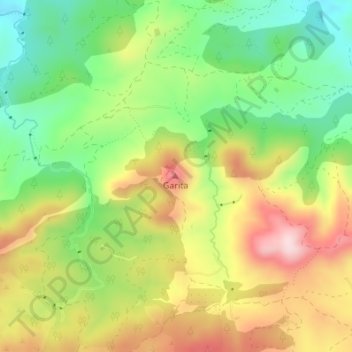
Name: Topografische Karte Garita, Höhe, Relief.
Ort: Garita, Lorca, Alto Guadalentín, España (37.65907 -1.94527 37.65917 -1.94517)
Durchschnittliche Höhe: 837 m
Minimale Höhe: 698 m
Maximale Höhe: 1.005 m
Andere topografische Karten
Klicken Sie auf eine Karte, um ihre Topografie, ihre Höhe und ihr Relief anzuzeigen.
El Palancar
España > Alto Guadalentín > Lorca
El Palancar, Zarzadilla de Totana, Lorca, Alto Guadalentín, 30800, España
Durchschnittliche Höhe: 822 m
Torrealvilla
España > Alto Guadalentín > Lorca
Torrealvilla, Lorca, Alto Guadalentín, España
Durchschnittliche Höhe: 503 m
Molino de Viento
España > Alto Guadalentín > Lorca
Molino de Viento, Lorca, Alto Guadalentín, España
Durchschnittliche Höhe: 324 m