
Topografische Karte Lakeville
Interaktive Karte
Klicken Sie auf die Karte, um die Höhe anzuzeigen.
Über diese Karte
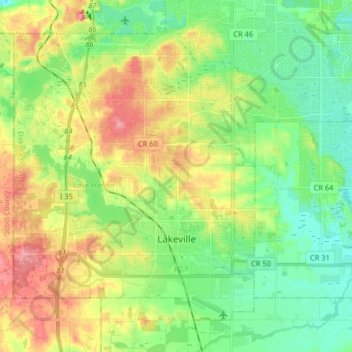
Name: Topografische Karte Lakeville, Höhe, Relief.
Ort: Lakeville, Dakota County, Minnesota, 55044, United States (44.62344 -93.31873 44.71754 -93.15640)
Durchschnittliche Höhe: 305 m
Minimale Höhe: 271 m
Maximale Höhe: 359 m
Andere topografische Karten
Klicken Sie auf eine Karte, um ihre Topografie, ihre Höhe und ihr Relief anzuzeigen.
Apple Valley
United States > Minnesota > Dakota County
Apple Valley, Dakota County, Minnesota, 55124, United States
Durchschnittliche Höhe: 301 m
Eagan
United States > Minnesota > Dakota County
Eagan, Dakota County, Minnesota, United States
Durchschnittliche Höhe: 267 m
Hastings
United States > Minnesota > Dakota County > Hastings > Hastings
Hastings, Dakota County, Minnesota, 55033, United States
Durchschnittliche Höhe: 243 m
Burnsville
United States > Minnesota > Dakota County > Burnsville
Burnsville, Dakota County, Minnesota, United States
Durchschnittliche Höhe: 271 m
Rosemount
United States > Minnesota > Dakota County > Rosemount
Rosemount, Dakota County, Minnesota, 55068, United States
Durchschnittliche Höhe: 287 m
Farmington
United States > Minnesota > Dakota County
Farmington, Dakota County, Minnesota, 55024, United States
Durchschnittliche Höhe: 280 m