
Topografische Karte Salamonie Lake
Interaktive Karte
Klicken Sie auf die Karte, um die Höhe anzuzeigen.
Über diese Karte
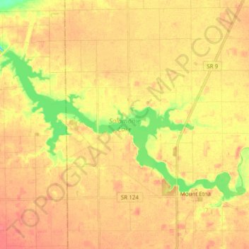
Name: Topografische Karte Salamonie Lake, Höhe, Relief.
Durchschnittliche Höhe: 247 m
Minimale Höhe: 211 m
Maximale Höhe: 267 m
Andere topografische Karten
Klicken Sie auf eine Karte, um ihre Topografie, ihre Höhe und ihr Relief anzuzeigen.
Dearborn County
Manchester Township, Dearborn County, Indiana, USA
Durchschnittliche Höhe: 265 m
Kankakee River
Kankakee River, Newton County, Indiana, 46379, USA
Durchschnittliche Höhe: 207 m
Tippecanoe River
Tippecanoe River, Fulton County, Indiana, USA
Durchschnittliche Höhe: 241 m
Mount Sinai
USA > Indiana > Mount Sinai
Mount Sinai, Hogan Township, Dearborn County, Indiana, USA
Durchschnittliche Höhe: 241 m
Georgetown
USA > Indiana > Georgetown
Georgetown, Randolph County, Indiana, 47340, USA
Durchschnittliche Höhe: 316 m
Cagles Mill Lake
Cagles Mill Lake, Black Hawk Road, Cunot, Owen County, Indiana, 47868, USA
Durchschnittliche Höhe: 222 m
McCormick's Creek State Park
USA > Indiana > Highets Corner
McCormick's Creek State Park, Highets Corner, Owen County, Indiana, USA
Durchschnittliche Höhe: 205 m
Salamonie River
Salamonie River, Huntington County, Indiana, 46792, USA
Durchschnittliche Höhe: 256 m
Dearborn County
Sparta Township, Dearborn County, Indiana, 47032, USA
Durchschnittliche Höhe: 267 m
Hartford City
USA > Indiana > Hartford City
Hartford City, Blackford County, Indiana, 47348, USA
Durchschnittliche Höhe: 276 m
Burns City
USA > Indiana > Burns City
Burns City, Martin County, Indiana, USA
Durchschnittliche Höhe: 201 m
Military Park
USA > Indiana > Indianapolis
Military Park, Indianapolis, Marion County, Indiana, USA
Durchschnittliche Höhe: 218 m
Wesselman Woods Nature Preserve
USA > Indiana > Evansville
Wesselman Woods Nature Preserve, Main Trail, Evansville, Vanderburgh County, Indiana, 47750, USA
Durchschnittliche Höhe: 120 m
Buttermilk Point
USA > Indiana > Buttermilk Point
Buttermilk Point, Kosciusko County, Indiana, 46732, USA
Durchschnittliche Höhe: 270 m
The Basin
USA > Indiana > Ramblewood
The Basin, East 700 South, Ramblewood, LaGrange County, Indiana, 46795, USA
Durchschnittliche Höhe: 302 m
Tanners Creek
Tanners Creek, Miller Township, Dearborn County, Indiana, 47025, USA
Durchschnittliche Höhe: 188 m
The Mounds
The Mounds, Franklin County, Indiana, 47012-7741, USA
Durchschnittliche Höhe: 247 m
New Bellsville
USA > Indiana > New Bellsville
New Bellsville, Brown County, Indiana, USA
Durchschnittliche Höhe: 224 m
Knightsville
USA > Indiana > Knightsville
Knightsville, Clay County, Indiana, 47857, USA
Durchschnittliche Höhe: 207 m
townsend park
townsend park, Marion, Grant County, Indiana, USA
Durchschnittliche Höhe: 254 m
Mississinewa Lake
USA > Indiana > College Corner
Mississinewa Lake, South 600 West, College Corner, Wabash County, Indiana, USA
Durchschnittliche Höhe: 241 m
bacon swamp
bacon swamp, East Northgate Street, Dawnbury, Marion County, Indiana, 46220, USA
Durchschnittliche Höhe: 230 m
McCloud Nature Park
McCloud Nature Park, Hendricks County, Indiana, USA
Durchschnittliche Höhe: 274 m
New Waverly
USA > Indiana > New Waverly
New Waverly, Cass County, Indiana, 46961, USA
Durchschnittliche Höhe: 215 m
Middle Fork of Wildcat Creek
Middle Fork of Wildcat Creek, Clinton County, Indiana, 46065, USA
Durchschnittliche Höhe: 215 m
Moran Park
Moran Park, Elkhart, Elkhart County, Indiana, 46515, USA
Durchschnittliche Höhe: 232 m
Cherryvale
USA > Indiana > Cherryvale
Cherryvale, Vigo County, Indiana, 47878, USA
Durchschnittliche Höhe: 186 m
Potato Creek State Park
USA > Indiana > Pine Station
Potato Creek State Park, Pine Station, Saint Joseph County, Indiana, USA
Durchschnittliche Höhe: 239 m
Woodville Hills
USA > Indiana > Woodville Hills
Woodville Hills, Monroe County, Indiana, USA
Durchschnittliche Höhe: 196 m
Cowles Bog
USA > Indiana > Dune Acres
Cowles Bog, Cowles Bog Trail, Dune Acres, Porter County, Indiana, 46304, USA
Durchschnittliche Höhe: 191 m
Patoka River
Patoka River, Dubois County, Indiana, 47527, USA
Durchschnittliche Höhe: 162 m