
Spenden
Rüste dich für dein nächstes Abenteuer:
Als Amazon-Partner verdient diese Website an qualifizierten Käufen, ohne zusätzliche Kosten für Sie.
Topografische Karte Bonlez
Klicken Sie auf die Karte, um die Höhe anzuzeigen.
Spenden
Rüste dich für dein nächstes Abenteuer:
Als Amazon-Partner verdient diese Website an qualifizierten Käufen, ohne zusätzliche Kosten für Sie.
Über diese Karte
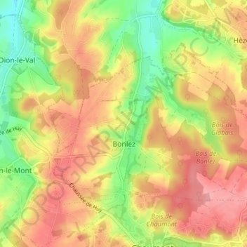
Name: Topografische Karte Bonlez, Höhe, Relief.
Durchschnittliche Höhe: 97 m
Minimale Höhe: 43 m
Maximale Höhe: 139 m
Spenden
Rüste dich für dein nächstes Abenteuer:
Als Amazon-Partner verdient diese Website an qualifizierten Käufen, ohne zusätzliche Kosten für Sie.
Andere topografische Karten
Klicken Sie auf eine Karte, um ihre Topografie, ihre Höhe und ihr Relief anzuzeigen.
Tout-Vent
Belgique > Brabant wallon > Nivelles > Chaumont-Gistoux > Bonlez
Durchschnittliche Höhe: 102 m
Panorama
Belgique > Brabant wallon > Nivelles > Chaumont-Gistoux > Bonlez
Durchschnittliche Höhe: 97 m
Spenden
Rüste dich für dein nächstes Abenteuer:
Als Amazon-Partner verdient diese Website an qualifizierten Käufen, ohne zusätzliche Kosten für Sie.
Spenden
Rüste dich für dein nächstes Abenteuer:
Als Amazon-Partner verdient diese Website an qualifizierten Käufen, ohne zusätzliche Kosten für Sie.
Bonly
Belgique > Brabant wallon > Nivelles > Chaumont-Gistoux > Dion-le-Mont
Durchschnittliche Höhe: 95 m
El Pirère
Belgique > Brabant wallon > Nivelles > Chaumont-Gistoux > El Pirère
Durchschnittliche Höhe: 111 m
Vieusart
Belgique > Brabant wallon > Nivelles > Chaumont-Gistoux > Vieusart
Durchschnittliche Höhe: 124 m
Spenden
Rüste dich für dein nächstes Abenteuer:
Als Amazon-Partner verdient diese Website an qualifizierten Käufen, ohne zusätzliche Kosten für Sie.
Grippelotte
Belgique > Brabant wallon > Nivelles > Chaumont-Gistoux > Dion-le-Mont
Durchschnittliche Höhe: 103 m