
Spenden
Rüste dich für dein nächstes Abenteuer:
Als Amazon-Partner verdient diese Website an qualifizierten Käufen, ohne zusätzliche Kosten für Sie.
Topografische Karte Placid Lakes
Klicken Sie auf die Karte, um die Höhe anzuzeigen.
Spenden
Rüste dich für dein nächstes Abenteuer:
Als Amazon-Partner verdient diese Website an qualifizierten Käufen, ohne zusätzliche Kosten für Sie.
Über diese Karte
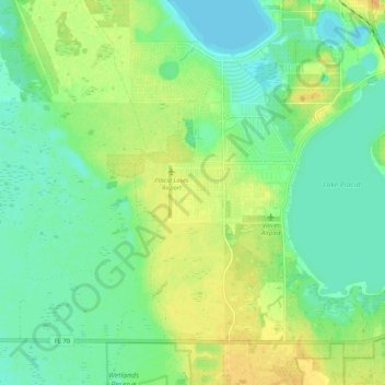
Name: Topografische Karte Placid Lakes, Höhe, Relief.
Ort: Placid Lakes, Highlands County, Florida, United States (27.20852 -81.45264 27.28178 -81.34697)
Durchschnittliche Höhe: 33 m
Minimale Höhe: 21 m
Maximale Höhe: 48 m
Spenden
Rüste dich für dein nächstes Abenteuer:
Als Amazon-Partner verdient diese Website an qualifizierten Käufen, ohne zusätzliche Kosten für Sie.
Andere topografische Karten
Klicken Sie auf eine Karte, um ihre Topografie, ihre Höhe und ihr Relief anzuzeigen.
Lake Placid
United States > Florida > Highlands County
Lake Placid, located in Highlands County, Florida, is situated on relatively flat terrain characteristic of the Florida Peninsula. The town's average elevation is approximately 150 feet (46 meters) above sea level, with elevations ranging from a minimum of about 69 feet (21 meters) to a maximum of about 165…
Durchschnittliche Höhe: 32 m
Spenden
Rüste dich für dein nächstes Abenteuer:
Als Amazon-Partner verdient diese Website an qualifizierten Käufen, ohne zusätzliche Kosten für Sie.
Spenden
Rüste dich für dein nächstes Abenteuer:
Als Amazon-Partner verdient diese Website an qualifizierten Käufen, ohne zusätzliche Kosten für Sie.