
Topografische Karte Ottmarsheim
Interaktive Karte
Klicken Sie auf die Karte, um die Höhe anzuzeigen.
Über diese Karte
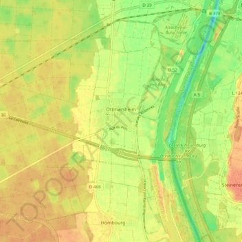
Name: Topografische Karte Ottmarsheim, Höhe, Relief.
Durchschnittliche Höhe: 224 m
Minimale Höhe: 200 m
Maximale Höhe: 240 m
Andere topografische Karten
Klicken Sie auf eine Karte, um ihre Topografie, ihre Höhe und ihr Relief anzuzeigen.
Masevaux-Niederbruck
France > Grand Est > Haut-Rhin
Masevaux-Niederbruck, Thann-Guebwiller, Haut-Rhin, Grand Est, France métropolitaine, 68290, France
Durchschnittliche Höhe: 577 m
Hagenthal-le-Bas
France > Grand Est > Haut-Rhin
Hagenthal-le-Bas, Mulhouse, Haut-Rhin, Grand Est, France métropolitaine, 68220, France
Durchschnittliche Höhe: 395 m
Ampfersbach
France > Grand Est > Haut-Rhin > Stosswihr
Ampfersbach, Stosswihr, Colmar-Ribeauvillé, Haut-Rhin, Grand Est, France métropolitaine, 68140, France
Durchschnittliche Höhe: 634 m
Steinbrunn-le-Haut
France > Grand Est > Haut-Rhin
Steinbrunn-le-Haut, Mulhouse, Haut-Rhin, Grand Est, France métropolitaine, 68440, France
Durchschnittliche Höhe: 320 m
Volgelsheim
France > Grand Est > Haut-Rhin
Volgelsheim, Colmar-Ribeauvillé, Haut-Rhin, Grand Est, France métropolitaine, 68600, France
Durchschnittliche Höhe: 193 m
Sainte-Marie-aux-Mines
France > Grand Est > Haut-Rhin > Sainte-Marie-aux-Mines
Sainte-Marie-aux-Mines, Colmar-Ribeauvillé, Haut-Rhin, Grand Est, France métropolitaine, 68160, France
Durchschnittliche Höhe: 713 m
Lapoutroie
France > Grand Est > Haut-Rhin > Lapoutroie
Lapoutroie, Colmar-Ribeauvillé, Haut-Rhin, Grand Est, France métropolitaine, 68650, France
Durchschnittliche Höhe: 698 m
Vosges
France > Grand Est > Haut-Rhin > Goldbach-Altenbach
Vosges, Goldbach-Altenbach, Thann-Guebwiller, Haut-Rhin, Grand Est, France métropolitaine, 68760, France
Durchschnittliche Höhe: 864 m
Wasserbourg
France > Grand Est > Haut-Rhin > Wasserbourg
Wasserbourg, Colmar-Ribeauvillé, Haut-Rhin, Grand Est, France métropolitaine, 68230, France
Durchschnittliche Höhe: 729 m
Katzenthal
France > Grand Est > Haut-Rhin > Katzenthal
Katzenthal, Colmar-Ribeauvillé, Haut-Rhin, Grand Est, France métropolitaine, 68230, France
Durchschnittliche Höhe: 293 m
Eschbach-au-Val
France > Grand Est > Haut-Rhin > Eschbach-au-Val
Eschbach-au-Val, Colmar-Ribeauvillé, Haut-Rhin, Grand Est, France métropolitaine, 68140, France
Durchschnittliche Höhe: 630 m
Storckensohn
France > Grand Est > Haut-Rhin > Storckensohn
Storckensohn, Thann-Guebwiller, Haut-Rhin, Grand Est, France métropolitaine, 68470, France
Durchschnittliche Höhe: 675 m
Sondernach
France > Grand Est > Haut-Rhin > Sondernach
Sondernach, Colmar-Ribeauvillé, Haut-Rhin, Grand Est, France métropolitaine, 68380, France
Durchschnittliche Höhe: 931 m
Masevaux
France > Grand Est > Haut-Rhin > Masevaux-Niederbruck
Masevaux, Masevaux-Niederbruck, Thann-Guebwiller, Haut-Rhin, Grand Est, France métropolitaine, 68290, France
Durchschnittliche Höhe: 577 m
Ribeauvillé
France > Grand Est > Haut-Rhin > Ribeauvillé
Ribeauvillé, Colmar-Ribeauvillé, Haut-Rhin, Grand Est, France métropolitaine, 68150, France
Durchschnittliche Höhe: 395 m
Husseren-les-Châteaux
France > Grand Est > Haut-Rhin > Husseren-les-Châteaux
Husseren-les-Châteaux, Colmar-Ribeauvillé, Haut-Rhin, Grand Est, France métropolitaine, 68420, France
Durchschnittliche Höhe: 398 m
Kaysersberg
France > Grand Est > Haut-Rhin > Kaysersberg-Vignoble
Kaysersberg, Kaysersberg-Vignoble, Colmar-Ribeauvillé, Haut-Rhin, Grand Est, France métropolitaine, 68240, France
Durchschnittliche Höhe: 523 m
Niedermorschwihr
France > Grand Est > Haut-Rhin
Niedermorschwihr, Colmar-Ribeauvillé, Haut-Rhin, Grand Est, France métropolitaine, 68230, France
Durchschnittliche Höhe: 339 m