
Spenden
Rüste dich für dein nächstes Abenteuer:
Als Amazon-Partner verdient diese Website an qualifizierten Käufen, ohne zusätzliche Kosten für Sie.
Topografische Karte Woodbridge
Klicken Sie auf die Karte, um die Höhe anzuzeigen.
Spenden
Rüste dich für dein nächstes Abenteuer:
Als Amazon-Partner verdient diese Website an qualifizierten Käufen, ohne zusätzliche Kosten für Sie.
Woodbridge
The Suffolk Traveller suggests a similar origin to The Dictionary but originating from a bridge over a hollow way that leads from Woodbridge Market Place to the Ipswich. But this is disputed by Rev. Thomas Carthew, then perpetual curate of Woodbridge who points out that the bridge had existed for less than a hundred years at that point and therefore was not old enough to be the source of the name. He instead suggests Oden or Woden (Odin) and Burgh, Bury, or Brigg (town). The Topographical Dictionary of England suggests a combination of Woden and Bryge.
Spenden
Rüste dich für dein nächstes Abenteuer:
Als Amazon-Partner verdient diese Website an qualifizierten Käufen, ohne zusätzliche Kosten für Sie.
Über diese Karte
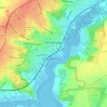
Name: Topografische Karte Woodbridge, Höhe, Relief.
Ort: Woodbridge, East Suffolk, Suffolk, England, United Kingdom (52.07639 1.28439 52.10577 1.32901)
Durchschnittliche Höhe: 19 m
Minimale Höhe: -5 m
Maximale Höhe: 46 m
Spenden
Rüste dich für dein nächstes Abenteuer:
Als Amazon-Partner verdient diese Website an qualifizierten Käufen, ohne zusätzliche Kosten für Sie.
Andere topografische Karten
Klicken Sie auf eine Karte, um ihre Topografie, ihre Höhe und ihr Relief anzuzeigen.
Shingle Street
United Kingdom > England > Suffolk > East Suffolk > Bawdsey
Durchschnittliche Höhe: 2 m
Spenden
Rüste dich für dein nächstes Abenteuer:
Als Amazon-Partner verdient diese Website an qualifizierten Käufen, ohne zusätzliche Kosten für Sie.
Site of old Orfordness Lighthouse
United Kingdom > England > Suffolk > East Suffolk > Orford
Durchschnittliche Höhe: 0 m
Spenden
Rüste dich für dein nächstes Abenteuer:
Als Amazon-Partner verdient diese Website an qualifizierten Käufen, ohne zusätzliche Kosten für Sie.
Rendlesham UFO Landing Site #2
United Kingdom > England > Suffolk > East Suffolk > Butley Abbey
Durchschnittliche Höhe: 14 m
Spenden
Rüste dich für dein nächstes Abenteuer:
Als Amazon-Partner verdient diese Website an qualifizierten Käufen, ohne zusätzliche Kosten für Sie.
Gunton Sands
United Kingdom > England > Suffolk > East Suffolk > Lowestoft > Corton
Durchschnittliche Höhe: 10 m
Lowestoft Inner Harbour
United Kingdom > England > Suffolk > East Suffolk > Lowestoft > Oulton Broad
Durchschnittliche Höhe: 8 m
Spenden
Rüste dich für dein nächstes Abenteuer:
Als Amazon-Partner verdient diese Website an qualifizierten Käufen, ohne zusätzliche Kosten für Sie.
Sutton Hoo Archeological Site
United Kingdom > England > Suffolk > East Suffolk > Sutton
Durchschnittliche Höhe: 19 m
Spenden
Rüste dich für dein nächstes Abenteuer:
Als Amazon-Partner verdient diese Website an qualifizierten Käufen, ohne zusätzliche Kosten für Sie.
Campsea Ashe
United Kingdom > England > Suffolk > East Suffolk > Campsea Ashe
Durchschnittliche Höhe: 21 m
Spenden
Rüste dich für dein nächstes Abenteuer:
Als Amazon-Partner verdient diese Website an qualifizierten Käufen, ohne zusätzliche Kosten für Sie.
Eygpt Wood
United Kingdom > England > Suffolk > East Suffolk > Trimley St Martin
Durchschnittliche Höhe: 16 m
Eygpt Wood
United Kingdom > England > Suffolk > East Suffolk > Trimley St Martin
Durchschnittliche Höhe: 16 m