
Topografische Karte Vessey
Interaktive Karte
Klicken Sie auf die Karte, um die Höhe anzuzeigen.
Über diese Karte
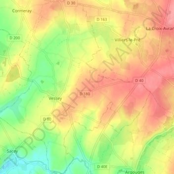
Name: Topografische Karte Vessey, Höhe, Relief.
Durchschnittliche Höhe: 56 m
Minimale Höhe: 12 m
Maximale Höhe: 90 m
Andere topografische Karten
Klicken Sie auf eine Karte, um ihre Topografie, ihre Höhe und ihr Relief anzuzeigen.
La Caserne
France > Normandie > Manche > Pontorson
La Caserne, Ardevon, Pontorson, Avranches, Manche, Normandie, France métropolitaine, 50170, France
Durchschnittliche Höhe: 6 m
Les Hautes Rivières
France > Normandie > Manche > Pontorson
Les Hautes Rivières, Moidrey, Pontorson, Avranches, Manche, Normandie, France métropolitaine, 50170, France
Durchschnittliche Höhe: 21 m