
Topografische Karte Ancient and Primeval Beech Forests of the Carpathians and Other Regions of Europe
Interaktive Karte
Klicken Sie auf die Karte, um die Höhe anzuzeigen.
Über diese Karte
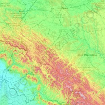
Name: Topografische Karte Ancient and Primeval Beech Forests of the Carpathians and Other Regions of Europe, Höhe, Relief.
Durchschnittliche Höhe: 467 m
Minimale Höhe: 98 m
Maximale Höhe: 2.008 m
Andere topografische Karten
Klicken Sie auf eine Karte, um ihre Topografie, ihre Höhe und ihr Relief anzuzeigen.
Hoverla
In the 20th century, the mountain increasingly gained popularity as an extreme sports site. Some routes are classified as 1A in the winter period (from late autumn to May), according to the Soviet grading system. The most popular approach to the summit starts from the tour-basa Zarosliak on the mountain's…
Durchschnittliche Höhe: 1.667 m