Geolokalisieren

Topografische Karte Warehorne

Klicken Sie auf die Karte, um die Höhe anzuzeigen.

Über diese Karte

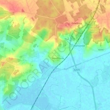
Name: Topografische Karte Warehorne, Höhe, Relief.

Ort: Warehorne, Ashford, Kent, England, United Kingdom (51.03136 0.80283 51.08868 0.85682)

Durchschnittliche Höhe: 20 m

Minimale Höhe: -2 m

Maximale Höhe: 59 m

Andere topografische Karten

Klicken Sie auf eine Karte, um ihre Topografie, ihre Höhe und ihr Relief anzuzeigen.

Old Wives Lees

United Kingdom > England > Kent > Ashford

Durchschnittliche Höhe: 66 m

Wye

United Kingdom > England > Kent > Ashford

Durchschnittliche Höhe: 55 m

Hamstreet

United Kingdom > England > Kent > Ashford

Durchschnittliche Höhe: 22 m

Pluckley Thorne

United Kingdom > England > Kent > Ashford > Pluckley

Durchschnittliche Höhe: 53 m

Hassell Street

United Kingdom > England > Kent > Ashford > Hastingleigh

Durchschnittliche Höhe: 134 m

Hinxhill

United Kingdom > England > Kent > Ashford

Durchschnittliche Höhe: 51 m

Stonebridge Green

United Kingdom > England > Kent > Ashford > Egerton

Durchschnittliche Höhe: 80 m

Potters Corner

United Kingdom > England > Kent > Ashford

Durchschnittliche Höhe: 61 m

Flip Out

United Kingdom > England > Kent > Ashford

Durchschnittliche Höhe: 43 m

Wye Downs

United Kingdom > England > Kent > Ashford

Durchschnittliche Höhe: 118 m

Stonestreet Green

United Kingdom > England > Kent > Ashford > Aldington

Durchschnittliche Höhe: 57 m

Vielen Dank für die Unterstützung dieser Website ❤️
Spenden

Standen

United Kingdom > England > Kent > Ashford > Biddenden

Durchschnittliche Höhe: 38 m

St Michaels

United Kingdom > England > Kent > Ashford

Durchschnittliche Höhe: 41 m

Great Chart

United Kingdom > England > Kent > Ashford

Durchschnittliche Höhe: 49 m

Aldington Frith

United Kingdom > England > Kent > Ashford

Durchschnittliche Höhe: 44 m

Boughton Lees

United Kingdom > England > Kent > Ashford

Durchschnittliche Höhe: 79 m

Stone Abbage

United Kingdom > England > Kent > Ashford

Durchschnittliche Höhe: 47 m

Cheeseman's Green

United Kingdom > England > Kent > Ashford

Durchschnittliche Höhe: 44 m

Stubbs Cross

United Kingdom > England > Kent > Ashford

Durchschnittliche Höhe: 43 m

Small Hythe

United Kingdom > England > Kent > Ashford

Durchschnittliche Höhe: 26 m

Egerton Forstal

United Kingdom > England > Kent > Ashford

Durchschnittliche Höhe: 50 m

Wye National Nature Reserve

United Kingdom > England > Kent > Ashford > Brook

Durchschnittliche Höhe: 123 m

Rüste dich für dein nächstes Abenteuer:

📱GPS fürs Wandern - Digitale Navigation für Tourenplanung
🧢Outdoor Sonnenhüte - UV-Schutz in den Bergen
🎒Rucksack-Regenschutz - Hält den Inhalt trocken, wenn das Wetter umschlägt
🧴Sonnencreme LSF 50 - Essentieller Schutz vor starker UV-Strahlung im Hochgebirge
🔭Kompaktes Fernrohr - Ideal zur Geländesichtung und Pfadfindung aus der Ferne

Als Amazon-Partner verdient diese Website an qualifizierten Käufen, ohne zusätzliche Kosten für Sie.