
Topografische Karte Northport
Interaktive Karte
Klicken Sie auf die Karte, um die Höhe anzuzeigen.
Über diese Karte
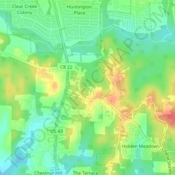
Name: Topografische Karte Northport, Höhe, Relief.
Ort: Northport, Tuscaloosa County, Alabama, United States (33.28725 -87.59484 33.28943 -87.59325)
Durchschnittliche Höhe: 89 m
Minimale Höhe: 65 m
Maximale Höhe: 123 m
Andere topografische Karten
Klicken Sie auf eine Karte, um ihre Topografie, ihre Höhe und ihr Relief anzuzeigen.
Northport
United States > Alabama > Tuscaloosa County > Northport
Northport, Tuscaloosa County, Alabama, United States
Durchschnittliche Höhe: 86 m
Indian Lake
United States > Alabama > Tuscaloosa County > Northport > Indian Lake
Indian Lake, Northport, Tuscaloosa County, Alabama, 35406, United States
Durchschnittliche Höhe: 79 m