Geolokalisieren

Topografische Karte 虎牢关村

Interaktive Karte

Klicken Sie auf die Karte, um die Höhe anzuzeigen.

Über diese Karte

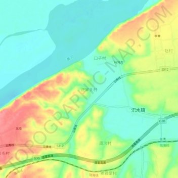
Name: Topografische Karte 虎牢关村, Höhe, Relief.

Ort: 虎牢关村, 郑州市, 河南省, 中国 (34.82998 113.17840 34.86998 113.21840)

Durchschnittliche Höhe: 128 m

Minimale Höhe: 95 m

Maximale Höhe: 182 m

Andere topografische Karten

Klicken Sie auf eine Karte, um ihre Topografie, ihre Höhe und ihr Relief anzuzeigen.

巩义市

中国 > 河南省 > 郑州市

巩义市, 郑州市, 河南省, 451200, 中国

Durchschnittliche Höhe: 334 m

雁鸣湖镇

中国 > 河南省 > 郑州市

雁鸣湖镇, 郑州市, 河南省, 中国

Durchschnittliche Höhe: 83 m

花园口镇

中国 > 河南省 > 郑州市

花园口镇, 郑州市, 金水区, 河南省, 中国

Durchschnittliche Höhe: 91 m

北林路街道

中国 > 河南省 > 郑州市

北林路街道, 金水区, 郑州市, 河南省, 中国

Durchschnittliche Höhe: 91 m

连天峰

中国 > 河南省 > 郑州市

连天峰, 郑州市, 河南省, 中国

Durchschnittliche Höhe: 1.043 m

未来路街道

中国 > 河南省 > 郑州市

未来路街道, 金水区, 郑州市, 河南省, 中国

Durchschnittliche Höhe: 95 m

二七区

中国 > 河南省 > 郑州市

二七区, 郑州市, 河南省, 中国

Durchschnittliche Höhe: 153 m

商都路街道

中国 > 河南省 > 郑州市

商都路街道, 管城回族区, 郑州市, 河南省, 中国

Durchschnittliche Höhe: 90 m

紫荆山公园

中国 > 河南省 > 郑州市 > 人民路街道

紫荆山公园, 人民路街道, 金水区, 郑州市, 河南省, 中国

Durchschnittliche Höhe: 100 m

惠济区

中国 > 河南省 > 郑州市

惠济区, 郑州市, 河南省, 中国

Durchschnittliche Höhe: 100 m

龙子湖街道

中国 > 河南省 > 郑州市 > 龙子湖街道

龙子湖街道, 金水区, 郑州市, 河南省, 中国

Durchschnittliche Höhe: 85 m

管城回族区

中国 > 河南省 > 郑州市

管城回族区, 郑州市, 河南省, 中国

Durchschnittliche Höhe: 112 m

野曹村

中国 > 河南省 > 郑州市 > 野曹村

野曹村, 郑州市, 河南省, 中国

Durchschnittliche Höhe: 113 m

人民路街道

中国 > 河南省 > 郑州市 > 人民路街道

人民路街道, 金水区, 郑州市, 河南省, 中国

Durchschnittliche Höhe: 102 m

郑州绿博园

中国 > 河南省 > 郑州市

郑州绿博园, 中牟县, 郑州市, 河南省, 中国

Durchschnittliche Höhe: 82 m

郑州文庙

中国 > 河南省 > 郑州市

郑州文庙, 管城回族区, 郑州市, 河南省, 中国

Durchschnittliche Höhe: 102 m

郭家咀水库

中国 > 河南省 > 郑州市

郭家咀水库, 二七区, 郑州市, 河南省, 中国

Durchschnittliche Höhe: 174 m