
Topografische Karte Pleasant Run Farm
Klicken Sie auf die Karte, um die Höhe anzuzeigen.
Über diese Karte
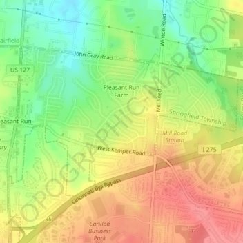
Name: Topografische Karte Pleasant Run Farm, Höhe, Relief.
Durchschnittliche Höhe: 239 m
Minimale Höhe: 199 m
Maximale Höhe: 275 m
Andere topografische Karten
Klicken Sie auf eine Karte, um ihre Topografie, ihre Höhe und ihr Relief anzuzeigen.
Cincinnati
United States > Ohio > Hamilton County
Cincinnati has several standard modes of transportation including sidewalks, roads, public transit, bicycle paths and airports. The city's hills preclude the regular street grid common to many cities built up in the 19th century, and outside of the downtown basin, regular street grids are rare except for in…
Durchschnittliche Höhe: 225 m
South Clippinger
United States > Ohio > Hamilton County > The Village of Indian Hill
Durchschnittliche Höhe: 252 m
Johnson Nature Preserve
United States > Ohio > Hamilton County > Montgomery
Durchschnittliche Höhe: 251 m
Saint Lawrence Corners
United States > Ohio > Hamilton County > Cincinnati
Durchschnittliche Höhe: 228 m
Norwood Heights
United States > Ohio > Hamilton County > Cincinnati > Norwood Heights
Durchschnittliche Höhe: 207 m