
Topografische Karte Combarbalá
Interaktive Karte
Klicken Sie auf die Karte, um die Höhe anzuzeigen.
Über diese Karte
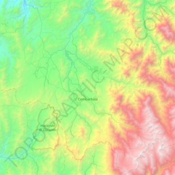
Name: Topografische Karte Combarbalá, Höhe, Relief.
Durchschnittliche Höhe: 1.444 m
Minimale Höhe: 223 m
Maximale Höhe: 4.111 m
Combarbalá is the capital city of the commune of Combarbala. It is located in the Limarí Province, Region of Coquimbo, at an elevation of 900 m (2,952 ft). It is known for the tourist astronomic observatory Cruz del Sur; the petroglyphs of Rincon las Chilcas; its typical handcraft made of the unique combarbalita stone; the classical basketball match at the end February; the Virgen de la Piedra catholic-pagan festivity, among other tourist attractions.
Andere topografische Karten
Klicken Sie auf eine Karte, um ihre Topografie, ihre Höhe und ihr Relief anzuzeigen.
Río Hurtado
Chile > Coquimbo Region > Provincia de Limarí
Río Hurtado, Provincia de Limarí, Coquimbo Region, Chile
Durchschnittliche Höhe: 2.126 m