
Topografische Karte Fritch
Interaktive Karte
Klicken Sie auf die Karte, um die Höhe anzuzeigen.
Über diese Karte
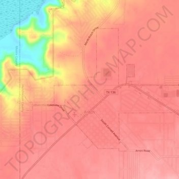
Name: Topografische Karte Fritch, Höhe, Relief.
Ort: Fritch, Hutchinson County, Texas, United States (35.63090 -101.62344 35.65886 -101.57331)
Durchschnittliche Höhe: 965 m
Minimale Höhe: 883 m
Maximale Höhe: 988 m
Fritch is primarily a bedroom community, with the majority of citizens commuting to nearby Borger and Amarillo for work. Major employers in the area include Pantex, ConocoPhillips, and Agrium, all located within a short distance of Fritch. Due to its nature as a commuting town, Fritch differs from most small towns in the region, which rely more on agriculture as their economic base. Though several large ranches are adjacent to the town, little to no farming occurs due to the uneven topography, and the town has few agriculture-related services.
Andere topografische Karten
Klicken Sie auf eine Karte, um ihre Topografie, ihre Höhe und ihr Relief anzuzeigen.
Phillips
United States > Texas > Hutchinson County
Phillips, Hutchinson County, Texas, 79007, United States
Durchschnittliche Höhe: 905 m
Stinnett
United States > Texas > Hutchinson County
Stinnett, Hutchinson County, Texas, United States
Durchschnittliche Höhe: 977 m
Lake Meredith
United States > Texas > Hutchinson County
Lake Meredith, Hutchinson County, Texas, United States
Durchschnittliche Höhe: 906 m
Borger
United States > Texas > Hutchinson County
Borger, Hutchinson County, Texas, 79007, United States
Durchschnittliche Höhe: 929 m