
Topografische Karte Jutogh
Interaktive Karte
Klicken Sie auf die Karte, um die Höhe anzuzeigen.
Über diese Karte
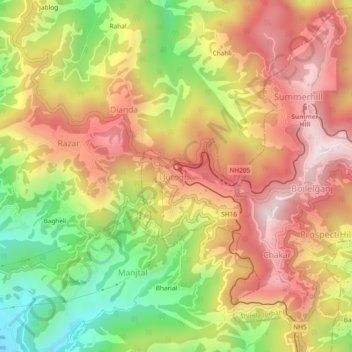
Name: Topografische Karte Jutogh, Höhe, Relief.
Durchschnittliche Höhe: 1.785 m
Minimale Höhe: 1.349 m
Maximale Höhe: 2.150 m
Jutogh is located at 31°06′N 77°07′E / 31.1°N 77.12°E / 31.1; 77.12 near Totu, an important suburb of Shimla city. It has an average elevation of 1729 metres (5673 feet), a total green area of 112.62 Acres, and a public garden known as Cantt. Board Public Garden.
Andere topografische Karten
Klicken Sie auf eine Karte, um ihre Topografie, ihre Höhe und ihr Relief anzuzeigen.
Chakar
India > Himachal Pradesh > Shimla (urban)
Chakar, Shimla (urban), Shimla District, Himachal Pradesh, 171005, India
Durchschnittliche Höhe: 1.796 m
Bharari
India > Himachal Pradesh > Shimla (urban)
Bharari, Shimla (urban), Shimla District, Himachal Pradesh, 171003, India
Durchschnittliche Höhe: 1.861 m
Shimla
India > Himachal Pradesh > Shimla (urban)
Shimla, Shimla (urban), Shimla District, Himachal Pradesh, 171001, India
Durchschnittliche Höhe: 1.557 m