
Topografische Karte Sanok
Interaktive Karte
Klicken Sie auf die Karte, um die Höhe anzuzeigen.
Über diese Karte
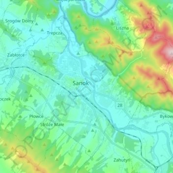
Name: Topografische Karte Sanok, Höhe, Relief.
Ort: Sanok, Sanok County, Subcarpathian Voivodeship, Poland (49.52281 22.14730 49.59510 22.28378)
Durchschnittliche Höhe: 354 m
Minimale Höhe: 271 m
Maximale Höhe: 666 m
This historic city is situated on the San River at the foot of Castle Hill in the Lesser Poland (Małopolska) region. It lies in a wooded, hilly area near the national road number 28, which runs along southern Poland, from Ustrzyki Dolne to Wadowice (340 km or 211 mi away). It is located in the heartland of the Pogórze Bukowskie part of Doły (Pits), and its average elevation is 300 m (984 ft) above sea level, although there are some hills located within the confines of the city.