
Topografische Karte Brownsville
Interaktive Karte
Klicken Sie auf die Karte, um die Höhe anzuzeigen.
Über diese Karte
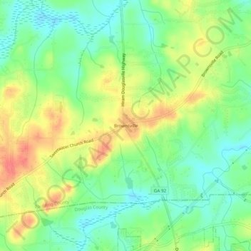
Name: Topografische Karte Brownsville, Höhe, Relief.
Ort: Brownsville, Paulding County, Georgia, 30134, United States (33.77955 -84.77744 33.81955 -84.73744)
Durchschnittliche Höhe: 299 m
Minimale Höhe: 274 m
Maximale Höhe: 332 m
Andere topografische Karten
Klicken Sie auf eine Karte, um ihre Topografie, ihre Höhe und ihr Relief anzuzeigen.
Cross Roads
United States > Georgia > Paulding County
Cross Roads, Paulding County, Georgia, United States
Durchschnittliche Höhe: 293 m
Nebo
United States > Georgia > Paulding County > Hiram
Nebo, Hiram, Paulding County, Georgia, 30140, United States
Durchschnittliche Höhe: 317 m
New Hope
United States > Georgia > Paulding County
New Hope, Country Acres, Paulding County, Georgia, 30132, United States
Durchschnittliche Höhe: 317 m
Braswell
United States > Georgia > Paulding County
Braswell, Paulding County, Georgia, United States
Durchschnittliche Höhe: 329 m
Yorkville
United States > Georgia > Paulding County
Yorkville, Paulding County, Georgia, 30153, United States
Durchschnittliche Höhe: 390 m
Ash
United States > Georgia > Paulding County
Ash, Paulding County, Georgia, 30140, United States
Durchschnittliche Höhe: 319 m
Dallas
United States > Georgia > Paulding County
Dallas, Paulding County, Georgia, United States
Durchschnittliche Höhe: 307 m
Hiram
United States > Georgia > Paulding County
Hiram, Paulding County, Georgia, United States
Durchschnittliche Höhe: 306 m
Hickory Gap
United States > Georgia > Paulding County > Hickory Gap
Hickory Gap, Paulding County, Georgia, 30140, United States
Durchschnittliche Höhe: 318 m
Ray Mountain
United States > Georgia > Paulding County
Ray Mountain, Paulding County, Georgia, 30132, United States
Durchschnittliche Höhe: 306 m