
Topografische Karte Vigan
Interaktive Karte
Klicken Sie auf die Karte, um die Höhe anzuzeigen.
Vigan
Vigan is situated in a Quaternary Age sedimentary plain called the Vigan-Bantay Plain which is part of the Ilocos coastal plain. The Vigan-Bantay Plain is bounded on the east by a moderately rugged Miocene sediments consisting of interbedded sandstones and shale to very rugged Meta-volcanics and Meta sediment topography; on the south is the Municipality of Santa where the north–south trending fault terminates; to the west is the South China Sea; while the northern boundary opens to the northern extension of the Ilocos coastal plain.
Über diese Karte
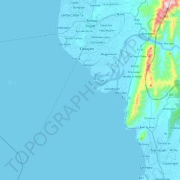
Name: Topografische Karte Vigan, Höhe, Relief.
Ort: Vigan, Ilocos Sur, Ilocos Region, 2700, Philippines (17.39840 120.19585 17.59134 120.43231)
Durchschnittliche Höhe: 34 m
Minimale Höhe: -1 m
Maximale Höhe: 748 m
Andere topografische Karten
Klicken Sie auf eine Karte, um ihre Topografie, ihre Höhe und ihr Relief anzuzeigen.