
Topografische Karte Isla Alejandro Selkirk
Interaktive Karte
Klicken Sie auf die Karte, um die Höhe anzuzeigen.
Isla Alejandro Selkirk
Alejandro Selkirk has a subtropical climate, moderated by the cold Humboldt Current and the southeast trade winds. Temperatures range from 3 °C (37 °F) to 34 °C (93 °F), with an annual mean of 15.4 °C (59.7 °F). Higher elevations are generally cooler. Average annual precipitation is 1,081 mm (42.6 in), varying from 318 mm (12.5 in) to 1,698 mm (66.9 in) year to year. Rainfall is higher in the winter months, and varies with elevation and exposure; elevations above 500 m (1,640 ft) experience almost daily rainfall.
Über diese Karte
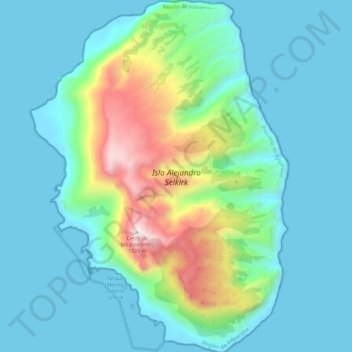
Name: Topografische Karte Isla Alejandro Selkirk, Höhe, Relief.
Durchschnittliche Höhe: 265 m
Minimale Höhe: -4 m
Maximale Höhe: 1.352 m