
Topografische Karte Bugsuk Island
Interaktive Karte
Klicken Sie auf die Karte, um die Höhe anzuzeigen.
Über diese Karte
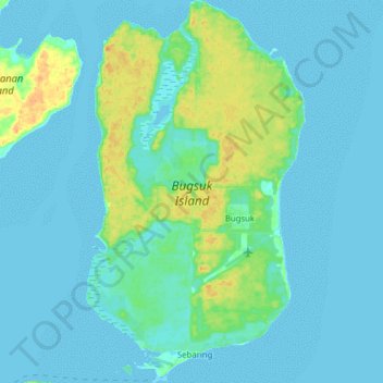
Name: Topografische Karte Bugsuk Island, Höhe, Relief.
Ort: Bugsuk Island, Balabac, Palawan, Mimaropa, Philippines (8.17579 117.26322 8.33059 117.35285)
Durchschnittliche Höhe: 6 m
Minimale Höhe: -2 m
Maximale Höhe: 28 m
Andere topografische Karten
Klicken Sie auf eine Karte, um ihre Topografie, ihre Höhe und ihr Relief anzuzeigen.
San Vicente
San Vicente, Palawan, Mimaropa, 5309, Philippines
Durchschnittliche Höhe: 8 m
El Nido
El Nido, Palawan, Mimaropa, 5313, Philippines
Durchschnittliche Höhe: 33 m
Man-udoc
Philippines > Palawan > Puerto Princesa > Man-udoc
Man-udoc, Puerto Princesa, Palawan, Mimaropa, Philippines
Durchschnittliche Höhe: 37 m
Bacungan
Philippines > Palawan > Bacungan
Bacungan, Palawan, Mimaropa, Philippines
Durchschnittliche Höhe: 22 m
Port Barton
Philippines > Palawan > Port Barton
Port Barton, Roxas, Palawan, Mimaropa, 5309, Philippines
Durchschnittliche Höhe: 79 m
Puerto Princesa
Philippines > Palawan > Puerto Princesa
Puerto Princesa, Palawan, Mimaropa, 5300, Philippines
Durchschnittliche Höhe: 92 m