
Topografische Karte Parma
Interaktive Karte
Klicken Sie auf die Karte, um die Höhe anzuzeigen.
Über diese Karte
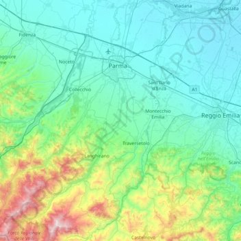
Name: Topografische Karte Parma, Höhe, Relief.
Ort: Parma, Emilia-Romagna, 43021, Italy (44.43410 10.03825 44.93804 10.44545)
Durchschnittliche Höhe: 280 m
Minimale Höhe: 17 m
Maximale Höhe: 1.551 m
Andere topografische Karten
Klicken Sie auf eine Karte, um ihre Topografie, ihre Höhe und ihr Relief anzuzeigen.
Pianta
Italy > Emilia-Romagna > Castel Guelfo di Bologna > Pianta
Pianta, Castel Guelfo di Bologna, Nuovo Circondario Imolese, Bologna, Emilia-Romagna, 40032, Italy
Durchschnittliche Höhe: 38 m
Reggiolo
Italy > Emilia-Romagna > Reggiolo
Reggiolo, Bassa Reggiana, RE, Emilia-Romagna, 42046, Italy
Durchschnittliche Höhe: 19 m
Preda
Italy > Emilia-Romagna > Preda
Preda, PC, Emilia-Romagna, 29021, Italy
Durchschnittliche Höhe: 569 m
Baiso
Italy > Emilia-Romagna > Baiso
Baiso, Tresinaro - Secchia, Reggio nell'Emilia, Emilia-Romagna, 42031, Italy
Durchschnittliche Höhe: 438 m