
Topografische Karte Mount Narodnaya
Interaktive Karte
Klicken Sie auf die Karte, um die Höhe anzuzeigen.
Über diese Karte
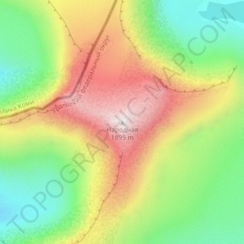
Name: Topografische Karte Mount Narodnaya, Höhe, Relief.
Durchschnittliche Höhe: 1.437 m
Minimale Höhe: 1.096 m
Maximale Höhe: 1.893 m
Mount Narodnaya (also known as Naroda and Poenurr; Russian: гора Народная, Komi: Народа-Из ("People's Mountain"), Mansi: Поэӈ-ур, Поэн-урр) is the highest peak of the Urals in Russia. Its elevation is 1,894 metres (6,214 ft). It is located on the border between Khanty–Mansi Autonomous Okrug in Tyumen Oblast and Komi Republic, the highest point being 0.5 km to the east from the border. The name may refer to Naroda River, which originates from the mount, located in the Research Range.
Andere topografische Karten
Klicken Sie auf eine Karte, um ihre Topografie, ihre Höhe und ihr Relief anzuzeigen.
Beryozovo
Russia > Khanty-Mansiysk Autonomous Okrug – Ugra > Beryozovsky District
Beryozovo, Beryozovsky District, Khanty-Mansiysk Autonomous Okrug – Ugra, Ural Federal District, Russia
Durchschnittliche Höhe: 46 m
Ural Mountains
Russia > Khanty-Mansiysk Autonomous Okrug – Ugra > Beryozovsky District
Ural Mountains, Beryozovsky District, Khanty-Mansiysk Autonomous Okrug – Ugra, Ural Federal District, Russia
Durchschnittliche Höhe: 1.435 m
Манси
Russia > Khanty-Mansiysk Autonomous Okrug – Ugra > Beryozovsky District
Манси, Beryozovsky District, Khanty-Mansiysk Autonomous Okrug – Ugra, Ural Federal District, Russia
Durchschnittliche Höhe: 1.306 m