
Topografische Karte Gharyan
Interaktive Karte
Klicken Sie auf die Karte, um die Höhe anzuzeigen.
Gharyan
Gharyan experiences a hot semi-arid climate (Köppen climate classification BSh), with blazing summers and cool winters; its winters being one of the coldest in Libya. Due to its winter months being 5 °C or 9 °F degrees cooler than Tripoli, the locality sees a cooler variation of said climate, though its higher elevation also meant that the town gets a dozen millimetres more precipitation then Libya's capital city.
Über diese Karte
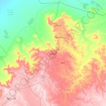
Name: Topografische Karte Gharyan, Höhe, Relief.
Ort: Gharyan, Jabal al Gharbi, Libya (32.01159 12.86115 32.33159 13.18115)
Durchschnittliche Höhe: 505 m
Minimale Höhe: 158 m
Maximale Höhe: 895 m