
Topografische Karte Spartanburg
Interaktive Karte
Klicken Sie auf die Karte, um die Höhe anzuzeigen.
Über diese Karte
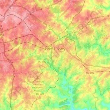
Name: Topografische Karte Spartanburg, Höhe, Relief.
Durchschnittliche Höhe: 234 m
Minimale Höhe: 172 m
Maximale Höhe: 279 m
Andere topografische Karten
Klicken Sie auf eine Karte, um ihre Topografie, ihre Höhe und ihr Relief anzuzeigen.
Mayo
United States > South Carolina > Spartanburg County
Mayo, Spartanburg County, South Carolina, 29368, United States
Durchschnittliche Höhe: 252 m
Spartanburg
United States > South Carolina > Spartanburg County > Spartanburg
Spartanburg, Spartanburg County, South Carolina, 29305, United States
Durchschnittliche Höhe: 234 m
East Spartanburg
United States > South Carolina > Spartanburg County > Spartanburg
East Spartanburg, Spartanburg, Spartanburg County, South Carolina, 29302, United States
Durchschnittliche Höhe: 227 m