
Topografische Karte Cristalina
Interaktive Karte
Klicken Sie auf die Karte, um die Höhe anzuzeigen.
Über diese Karte
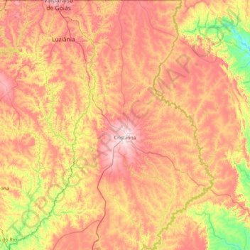
Name: Topografische Karte Cristalina, Höhe, Relief.
Durchschnittliche Höhe: 874 m
Minimale Höhe: 565 m
Maximale Höhe: 1.252 m
As the name indicates the town is famous for being one of the largest centers of production and commerce of precious and semi-precious stones and crystals in Brazil. The immense variety of stones (such as amethysts, sapphires, emeralds, blue topazes, and tourmaline) and of crystals (found in diverse sizes, shapes and colors) are responsible for the large number of tourists that visit the city. Because of the altitude the climate is mild, with temperatures between 10 and 28 degrees Celsius.
Andere topografische Karten
Klicken Sie auf eine Karte, um ihre Topografie, ihre Höhe und ihr Relief anzuzeigen.
Águas Lindas de Goiás
Brazil > Goiás > Região Integrada de Desenvolvimento do Distrito Federal e Entorno
Águas Lindas de Goiás, Região Geográfica Imediata de Águas Lindas de Goiás, Região Integrada de Desenvolvimento do Distrito Federal e Entorno, Região Geográfica Intermediária de Luziânia-Águas Lindas de Goiás, Goiás, Central-West Region, Brazil
Durchschnittliche Höhe: 1.063 m
Corumbá de Goiás
Brazil > Goiás > Região Integrada de Desenvolvimento do Distrito Federal e Entorno
Corumbá de Goiás, Região Geográfica Imediata de Anápolis, Região Integrada de Desenvolvimento do Distrito Federal e Entorno, Região Geográfica Intermediária de Goiânia, Goiás, Central-West Region, Brazil
Durchschnittliche Höhe: 1.003 m
Lago Azul
Brazil > Goiás > Região Integrada de Desenvolvimento do Distrito Federal e Entorno > Novo Gama
Lago Azul, Novo Gama, Região Geográfica Imediata de Luziânia, Região Integrada de Desenvolvimento do Distrito Federal e Entorno, Região Geográfica Intermediária de Luziânia-Águas Lindas de Goiás, Goiás, Central-West Region, 72865-105, Brazil
Durchschnittliche Höhe: 994 m