
Topografische Karte Isla Holbox
Interaktive Karte
Klicken Sie auf die Karte, um die Höhe anzuzeigen.
Über diese Karte
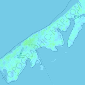
Name: Topografische Karte Isla Holbox, Höhe, Relief.
Ort: Isla Holbox, Lázaro Cárdenas, Quintana Roo, 77310, Mexico (21.50320 -87.39714 21.54308 -87.35236)
Durchschnittliche Höhe: 1 m
Minimale Höhe: -2 m
Maximale Höhe: 6 m
Andere topografische Karten
Klicken Sie auf eine Karte, um ihre Topografie, ihre Höhe und ihr Relief anzuzeigen.
Tulum
Like most of the Yucatan Peninsula Tulum is entirely flat with a gentle slope towards the sea, so from west to east, the area never reaches an altitude higher than 25 metres (82 ft) above sea level. The municipality is 5 metres (16 ft) above sea level on average.
Durchschnittliche Höhe: 10 m
Tulum
Like most of the Yucatan Peninsula Tulum is entirely flat with a gentle slope towards the sea, so from west to east, the area never reaches an altitude higher than 25 metres (82 ft) above sea level. The municipality is 5 metres (16 ft) above sea level on average.
Durchschnittliche Höhe: 10 m
Parque Nacional Costa Occidental de Isla Mujeres, Punta Cancún y Punta Nizuc
Mexico > Quintana Roo > Isla Mujeres > Isla Mujeres
Durchschnittliche Höhe: 3 m
Solidaridad
Like most of the Yucatan Peninsula, Solidaridad is almost entirely flat with a gentle slope towards the sea, so from west to east, most of the area never reaches an altitude above 25 metres (82 ft) above sea level.
Durchschnittliche Höhe: 13 m
Isla Cozumel
Mexico > Quintana Roo > Cozumel
Cozumel has 5 main piers. Punta Langosta, the International Pier (SSA), and Puerta Maya are all piers for cruise ships. A ferry pier in San Miguel is used for passenger ferries to and from Playa del Carmen, as well as for cruise ship tenders. A fifth pier south of downtown is used only for vehicle ferries.…
Durchschnittliche Höhe: 2 m
Cozumel
Large parts of the island are covered with mangrove forest which has many endemic animal species. Cozumel is a flat island based on limestone, resulting in a karst topography. The highest natural point on the island is less than 15 m (49 ft) above sea level. The cenotes are deep water-filled sinkholes formed…
Durchschnittliche Höhe: 1 m
Solidaridad
Like most of the Yucatan Peninsula, Solidaridad is almost entirely flat with a gentle slope towards the sea, so from west to east, most of the area never reaches an altitude above 25 metres (82 ft) above sea level.
Durchschnittliche Höhe: 13 m