
Topografische Karte Garden Lakes, City of Rome
Interaktive Karte
Klicken Sie auf die Karte, um die Höhe anzuzeigen.
Über diese Karte
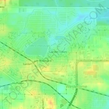
Name: Topografische Karte Garden Lakes, City of Rome, Höhe, Relief.
Durchschnittliche Höhe: 197 m
Minimale Höhe: 184 m
Maximale Höhe: 213 m
Andere topografische Karten
Klicken Sie auf eine Karte, um ihre Topografie, ihre Höhe und ihr Relief anzuzeigen.
Radio Springs
United States > Georgia > Floyd County
Radio Springs, Floyd County, Georgia, United States
Durchschnittliche Höhe: 243 m
Lindale
United States > Georgia > Floyd County
Lindale, Floyd County, Georgia, 30147, United States
Durchschnittliche Höhe: 229 m
Shannon
United States > Georgia > Floyd County
Shannon, Floyd County, Georgia, 30172, United States
Durchschnittliche Höhe: 211 m
Rome
United States > Georgia > Floyd County
Rome, Floyd County, Georgia, United States
Durchschnittliche Höhe: 211 m
Cave Spring
United States > Georgia > Floyd County
Cave Spring, Floyd County, Georgia, United States
Durchschnittliche Höhe: 237 m
Berryhill
United States > Georgia > Floyd County > Rome
Berryhill, Rome, Floyd County, Georgia, 30165, United States
Durchschnittliche Höhe: 207 m
Cave Spring
United States > Georgia > Floyd County > Cave Spring
Cave Spring, Floyd County, Georgia, 30124, United States
Durchschnittliche Höhe: 235 m