
Topografische Karte Platteville
Interaktive Karte
Klicken Sie auf die Karte, um die Höhe anzuzeigen.
Über diese Karte
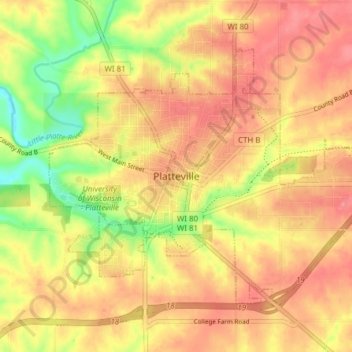
Name: Topografische Karte Platteville, Höhe, Relief.
Ort: Platteville, Grant County, Wisconsin, 53818, United States (42.71397 -90.50631 42.75469 -90.42960)
Durchschnittliche Höhe: 295 m
Minimale Höhe: 243 m
Maximale Höhe: 327 m
Platteville is the largest city in Grant County, Wisconsin. The population was 11,836 at the 2020 census, up from 11,224 at the 2010 census. Much of this growth is likely due to the enrollment increase of the University of Wisconsin–Platteville. It is the principal city of the Platteville Micropolitan Statistical area, which has an estimated population of 51,938. Platteville is located atop the greater Platte River valley in the southern Driftless Region of Wisconsin, an area known for its karst topography and rolling hills.
Andere topografische Karten
Klicken Sie auf eine Karte, um ihre Topografie, ihre Höhe und ihr Relief anzuzeigen.
Blue River
United States > Wisconsin > Grant County
Blue River, Grant County, Wisconsin, United States
Durchschnittliche Höhe: 223 m
Potosi
United States > Wisconsin > Grant County
Potosi, Grant County, Wisconsin, United States
Durchschnittliche Höhe: 264 m
Town of Potosi
United States > Wisconsin > Grant County
Town of Potosi, Grant County, Wisconsin, 53820, United States
Durchschnittliche Höhe: 251 m