
Topografische Karte Rumford
Interaktive Karte
Klicken Sie auf die Karte, um die Höhe anzuzeigen.
Über diese Karte
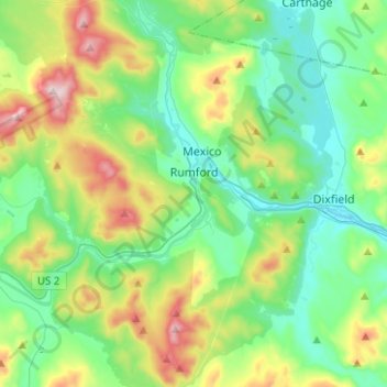
Name: Topografische Karte Rumford, Höhe, Relief.
Ort: Rumford, Oxford County, Maine, 04276, United States (44.45720 -70.73271 44.61602 -70.48286)
Durchschnittliche Höhe: 279 m
Minimale Höhe: 115 m
Maximale Höhe: 708 m
According to the United States Census Bureau, the town has a total area of 69.85 square miles (180.91 km2), of which 68.55 square miles (177.54 km2) is land and 1.30 square miles (3.37 km2) is water. Rumford is located where the Concord, Ellis, and Swift rivers drain into the Androscoggin river. Black Mountain, elevation 2,133 feet (650 m), and Rumford Whitecap, elevation 2,197 feet (670 m), are in the north.
Andere topografische Karten
Klicken Sie auf eine Karte, um ihre Topografie, ihre Höhe und ihr Relief anzuzeigen.
Sugarloaf
United States > Maine > Oxford County > Dixfield
Sugarloaf, Dixfield, Oxford County, Maine, 04224, United States
Durchschnittliche Höhe: 237 m
Greenwood
United States > Maine > Oxford County
Greenwood, Oxford County, Maine, 04255, United States
Durchschnittliche Höhe: 295 m
Milton Township
United States > Maine > Oxford County
Milton Township, Oxford County, Maine, 04219, United States
Durchschnittliche Höhe: 309 m
Pleasant Lake
United States > Maine > Oxford County > Otisfield
Pleasant Lake, Otisfield, Oxford County, Maine, 04270, United States
Durchschnittliche Höhe: 140 m
Paris
United States > Maine > Oxford County
Paris, Oxford County, Maine, 04281, United States
Durchschnittliche Höhe: 207 m
Woodstock
United States > Maine > Oxford County
Woodstock, Oxford County, Maine, 04219, United States
Durchschnittliche Höhe: 316 m
Upton
United States > Maine > Oxford County
Upton, Oxford County, Maine, 04261, United States
Durchschnittliche Höhe: 448 m
West Paris
United States > Maine > Oxford County
West Paris, Oxford County, Maine, 04289, United States
Durchschnittliche Höhe: 234 m
Bethel
United States > Maine > Oxford County
Bethel, Oxford County, Maine, 04217, United States
Durchschnittliche Höhe: 310 m
Stow
United States > Maine > Oxford County
Stow, Oxford County, Maine, 04037, United States
Durchschnittliche Höhe: 308 m
Plumbago Mountain
United States > Maine > Oxford County > Newry
Plumbago Mountain, Newry, Oxford County, Maine, 04261, United States
Durchschnittliche Höhe: 618 m
Denmark
United States > Maine > Oxford County
Denmark, Oxford County, Maine, 04022, United States
Durchschnittliche Höhe: 174 m
South Paris
United States > Maine > Oxford County > Paris
South Paris, Paris, Oxford County, Maine, 04281, United States
Durchschnittliche Höhe: 155 m
Sweden
United States > Maine > Oxford County
Sweden, Oxford County, Maine, 04040, United States
Durchschnittliche Höhe: 185 m
Norway
United States > Maine > Oxford County
Norway, Oxford County, Maine, 04268, United States
Durchschnittliche Höhe: 180 m