
Topografische Karte Muzo
Interaktive Karte
Klicken Sie auf die Karte, um die Höhe anzuzeigen.
Über diese Karte
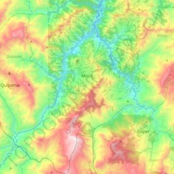
Name: Topografische Karte Muzo, Höhe, Relief.
Ort: Muzo, Occidente, Boyacá, Colombie (5.43279 -74.17663 5.60880 -74.04966)
Durchschnittliche Höhe: 1.017 m
Minimale Höhe: 433 m
Maximale Höhe: 1.916 m
Andere topografische Karten
Klicken Sie auf eine Karte, um ihre Topografie, ihre Höhe und ihr Relief anzuzeigen.
Villa de Leyva
Villa de Leyva, Ricaurte, Boyacá, RAP (Especial) Central, Colombie
Durchschnittliche Höhe: 2.416 m
Miraflores
Miraflores, Lengupá, Boyacá, RAP (Especial) Central, Colombie
Durchschnittliche Höhe: 1.943 m
Villa de Leyva
Colombie > Boyacá > Villa de Leyva
Villa de Leyva, Boyacá, 15401, Colombie
Durchschnittliche Höhe: 2.673 m