
Topografische Karte Dunmore
Interaktive Karte
Klicken Sie auf die Karte, um die Höhe anzuzeigen.
Über diese Karte
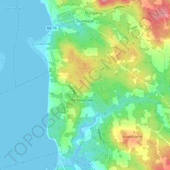
Name: Topografische Karte Dunmore, Höhe, Relief.
Durchschnittliche Höhe: 28 m
Minimale Höhe: -1 m
Maximale Höhe: 100 m
Andere topografische Karten
Klicken Sie auf eine Karte, um ihre Topografie, ihre Höhe und ihr Relief anzuzeigen.
Mabou Harbour
Canada > Nova Scotia > Municipality of the County of Inverness > West Mabou
Mabou Harbour, West Mabou, Municipality of the County of Inverness, Inverness County, Nova Scotia, Canada
Durchschnittliche Höhe: 51 m
Big Harbour Island
Canada > Nova Scotia > Municipality of the County of Inverness
Big Harbour Island, Municipality of the County of Inverness, Inverness County, Nova Scotia, Canada
Durchschnittliche Höhe: 3 m
Gull Island
Canada > Nova Scotia > Municipality of the County of Inverness > Big Harbour Island
Gull Island, Big Harbour Island, Municipality of the County of Inverness, Inverness County, Nova Scotia, Canada
Durchschnittliche Höhe: 74 m