
Topografische Karte Troy
Interaktive Karte
Klicken Sie auf die Karte, um die Höhe anzuzeigen.
Über diese Karte
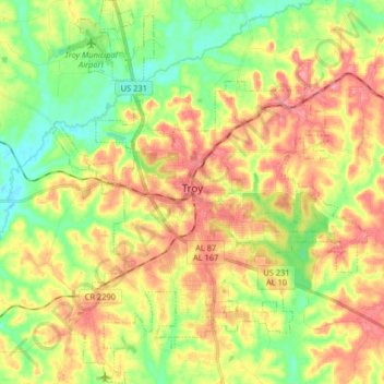
Name: Topografische Karte Troy, Höhe, Relief.
Ort: Troy, Pike County, Alabama, United States (31.73851 -86.02883 31.87597 -85.89627)
Durchschnittliche Höhe: 131 m
Minimale Höhe: 88 m
Maximale Höhe: 178 m
Troy is located at 31°48′32″N 85°58′12″W / 31.80889°N 85.97000°W / 31.80889; -85.97000 (31.808768, −85.969951). It is in the East Gulf Coastal Plains region of Alabama. It is located along the Troy Cuesta ridge, which runs across the state from east to west and is the boundary that separates the Chunnenuggee Hills and Southern Red Hills geographical boundaries. Elevations commonly reach 400 feet (120 m) in these hills and can reach up to 500 feet (150 m) in some areas. About 40 miles (64 km) north of Troy near the Montgomery area, the Chunnenuggee Hills region ends and the flat Black Prairie region begins, commonly known as the Black Belt region. About 60 miles (97 km) south of Troy in the Dothan area, the Southern Red Hills region ends and the Dougherty Plains region begins. Map
Andere topografische Karten
Klicken Sie auf eine Karte, um ihre Topografie, ihre Höhe und ihr Relief anzuzeigen.
Forest Circle
United States > Alabama > Pike County > Troy
Forest Circle, Troy, Pike County, Alabama, 36081, United States
Durchschnittliche Höhe: 142 m
Tarentum
United States > Alabama > Pike County > Tarentum
Tarentum, Pike County, Alabama, United States
Durchschnittliche Höhe: 122 m
Kent
United States > Alabama > Pike County > Kent
Kent, Pike County, Alabama, 36036, United States
Durchschnittliche Höhe: 121 m
Goshen
United States > Alabama > Pike County > Goshen
Goshen, Pike County, Alabama, United States
Durchschnittliche Höhe: 97 m