
Topografische Karte Millinocket
Interaktive Karte
Klicken Sie auf die Karte, um die Höhe anzuzeigen.
Über diese Karte
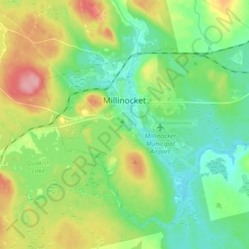
Name: Topografische Karte Millinocket, Höhe, Relief.
Ort: Millinocket, Penobscot County, Maine, 04462, United States (45.61065 -68.75326 45.68671 -68.62147)
Durchschnittliche Höhe: 140 m
Minimale Höhe: 100 m
Maximale Höhe: 218 m
The town is crossed by State Route 11 and State Route 157. The town of East Millinocket is located 8 miles (13 km) to the east. Millinocket is the closest town to Mount Katahdin, located in Baxter State Park 20 miles (32 km) to the northwest. At an elevation 5,270 feet (1,610 m), its summit is the highest point in Maine and the northern terminus of the Appalachian Trail.
Andere topografische Karten
Klicken Sie auf eine Karte, um ihre Topografie, ihre Höhe und ihr Relief anzuzeigen.
Sugar Island
United States > Maine > Penobscot County > Greenbush
Sugar Island, Greenbush, Penobscot County, Maine, 04418, United States
Durchschnittliche Höhe: 41 m
Lakeville
United States > Maine > Penobscot County
Lakeville, Penobscot County, Maine, United States
Durchschnittliche Höhe: 138 m
Plymouth
United States > Maine > Penobscot County
Plymouth, Penobscot County, Maine, 04969, United States
Durchschnittliche Höhe: 92 m
Tiger Rips
United States > Maine > Penobscot County
Tiger Rips, T6 R7 WELS, Penobscot County, Maine, United States
Durchschnittliche Höhe: 226 m
Enfield
United States > Maine > Penobscot County
Enfield, Penobscot County, Maine, 04493, United States
Durchschnittliche Höhe: 76 m
Passadumkeag
United States > Maine > Penobscot County
Passadumkeag, Penobscot County, Maine, 04475, United States
Durchschnittliche Höhe: 51 m
Orono
United States > Maine > Penobscot County
Orono, Penobscot County, Maine, United States
Durchschnittliche Höhe: 44 m
State Island
United States > Maine > Penobscot County
State Island, T2 R8 WELS, Penobscot County, Maine, United States
Durchschnittliche Höhe: 147 m
Carmel
United States > Maine > Penobscot County
Carmel, Penobscot County, Maine, 04419, United States
Durchschnittliche Höhe: 76 m
Burlington
United States > Maine > Penobscot County
Burlington, Penobscot County, Maine, 04417, United States
Durchschnittliche Höhe: 108 m
Webster Plantation
United States > Maine > Penobscot County
Webster Plantation, Penobscot County, Maine, United States
Durchschnittliche Höhe: 122 m
Bangor
United States > Maine > Penobscot County
Bangor, Penobscot County, Maine, 04401, United States
Durchschnittliche Höhe: 42 m
Glenburn
United States > Maine > Penobscot County
Glenburn, Penobscot County, Maine, 04401, United States
Durchschnittliche Höhe: 46 m
Howland
United States > Maine > Penobscot County
Howland, Penobscot County, Maine, 04448, United States
Durchschnittliche Höhe: 62 m
Levant
United States > Maine > Penobscot County
Levant, Penobscot County, Maine, 04456, United States
Durchschnittliche Höhe: 60 m
Lincoln
United States > Maine > Penobscot County > Lincoln
Lincoln, Penobscot County, Maine, 04457, United States
Durchschnittliche Höhe: 83 m
Lee
United States > Maine > Penobscot County > Lee
Lee, Penobscot County, Maine, 04455, United States
Durchschnittliche Höhe: 130 m
Eddington
United States > Maine > Penobscot County > Eddington
Eddington, Penobscot County, Maine, 04428, United States
Durchschnittliche Höhe: 51 m