
Topografische Karte City of Subotica
Interaktive Karte
Klicken Sie auf die Karte, um die Höhe anzuzeigen.
Über diese Karte
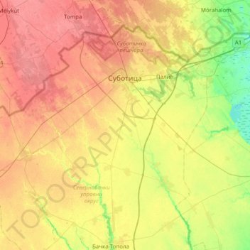
Name: Topografische Karte City of Subotica, Höhe, Relief.
Durchschnittliche Höhe: 111 m
Minimale Höhe: 80 m
Maximale Höhe: 142 m
Andere topografische Karten
Klicken Sie auf eine Karte, um ihre Topografie, ihre Höhe und ihr Relief anzuzeigen.
Subotica
Serbia > Vojvodina > North Backa Administrative District
It is located in the Pannonian Basin at 46.07° North, 19.68° East, at the altitude of 109m, about 10 kilometres (6 miles) from the border with Hungary, and is the northernmost city in Serbia. Lake Palić is in the immediate vicinity of the city. Sand dunes area Subotička Peščara is located north of the…
Durchschnittliche Höhe: 115 m