
Topografische Karte Palea Kameni
Interaktive Karte
Klicken Sie auf die Karte, um die Höhe anzuzeigen.
Über diese Karte
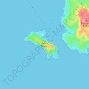
Name: Topografische Karte Palea Kameni, Höhe, Relief.
Durchschnittliche Höhe: 10 m
Minimale Höhe: 0 m
Maximale Höhe: 121 m
Andere topografische Karten
Klicken Sie auf eine Karte, um ihre Topografie, ihre Höhe und ihr Relief anzuzeigen.
Rhodos
Griechenland > Ägäis > Rhodos
Rhodos, Δήμος Ρόδου, Regionalbezirk Rhodos, Region Südliche Ägäis, Ägäis, 85100, Griechenland
Durchschnittliche Höhe: 29 m
Κλίμα
Κλίμα, Δήμος Κιμώλου, Regionalbezirk Milos, Region Südliche Ägäis, Ägäis, Griechenland
Durchschnittliche Höhe: 13 m
Naxos
Griechenland > Ägäis > Regionalbezirk Naxos
Naxos, Regionalbezirk Naxos, Region Südliche Ägäis, Ägäis, Griechenland
Durchschnittliche Höhe: 112 m
Rhodos
Griechenland > Ägäis > Rhodos
Rhodos, Δήμος Ρόδου, Regionalbezirk Rhodos, Region Südliche Ägäis, Ägäis, 85100, Griechenland
Durchschnittliche Höhe: 67 m
Δημοτική Ενότητα Θήρας
Griechenland > Ägäis > Δημοτική Ενότητα Θήρας
Δημοτική Ενότητα Θήρας, Δήμος Θήρας, Regionalbezirk Thira, Region Südliche Ägäis, Ägäis, Griechenland
Durchschnittliche Höhe: 12 m
Klima
Griechenland > Ägäis > Klima
Klima, Gemeinde Samos, Regionalbezirk Samos, Region Nördliche Ägäis, Ägäis, 83100, Griechenland
Durchschnittliche Höhe: 62 m
Andros
Andros, Gemeinde Andros, Regionalbezirk Andros, Region Südliche Ägäis, Ägäis, Griechenland
Durchschnittliche Höhe: 83 m
Gyali
Gyali, Δήμος Νισύρου, Regionalbezirk Kos, Region Südliche Ägäis, Ägäis, Griechenland
Durchschnittliche Höhe: 12 m
Nisyros
Nisyros, Δήμος Νισύρου, Regionalbezirk Kos, Region Südliche Ägäis, Ägäis, 85303, Griechenland
Durchschnittliche Höhe: 126 m
Lesbos
Griechenland > Ägäis > Mytilini
Lesbos, Mytilini, Δήμος Λέσβου, Region Nördliche Ägäis, Ägäis, 81100, Griechenland
Durchschnittliche Höhe: 74 m
Σαντορίνη
Σαντορίνη, Δήμος Θήρας, Regionalbezirk Thira, Region Südliche Ägäis, Ägäis, 84700 SANTORINI, Griechenland
Durchschnittliche Höhe: 17 m