
Topografische Karte Village of Horseheads
Interaktive Karte
Klicken Sie auf die Karte, um die Höhe anzuzeigen.
Über diese Karte
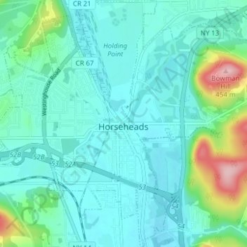
Name: Topografische Karte Village of Horseheads, Höhe, Relief.
Durchschnittliche Höhe: 298 m
Minimale Höhe: 263 m
Maximale Höhe: 454 m
Andere topografische Karten
Klicken Sie auf eine Karte, um ihre Topografie, ihre Höhe und ihr Relief anzuzeigen.
West Elmira
United States > New York > Chemung County
West Elmira, Town of Elmira, Chemung County, New York, 14905, United States
Durchschnittliche Höhe: 320 m
Brand Park
United States > New York > Chemung County > City of Elmira
Brand Park, City of Elmira, Chemung County, New York, United States
Durchschnittliche Höhe: 270 m
City of Elmira
United States > New York > Chemung County > City of Elmira
City of Elmira, Ashland, Chemung County, New York, United States
Durchschnittliche Höhe: 296 m
Village of Millport
United States > New York > Chemung County
Village of Millport, Town of Veteran, Chemung County, New York, United States
Durchschnittliche Höhe: 296 m
Langdon Hill
United States > New York > Chemung County
Langdon Hill, Chemung County, New York, 14838, United States
Durchschnittliche Höhe: 449 m
Lowman
United States > New York > Chemung County
Lowman, Town of Ashland, Chemung County, New York, 14894, United States
Durchschnittliche Höhe: 290 m