
Spenden
Rüste dich für dein nächstes Abenteuer:
Als Amazon-Partner verdient diese Website an qualifizierten Käufen, ohne zusätzliche Kosten für Sie.
Topografische Karte Nimpo Lake
Klicken Sie auf die Karte, um die Höhe anzuzeigen.
Spenden
Rüste dich für dein nächstes Abenteuer:
Als Amazon-Partner verdient diese Website an qualifizierten Käufen, ohne zusätzliche Kosten für Sie.
Nimpo Lake
Nimpo Lake is the jumping off point to the wilderness, much of it inaccessible to people except by floatplane or on foot. You can go flightseeing over Hunlen Falls, the third longest freefalling waterfall in Canada, or fly over the multicolored Rainbow Mountains or Monarch Mountain and see the pristine icefields. There is canoeing on the Turner Lake Chain in nearby Tweedsmuir Park, and a number of activities available to visitors of the area. These include fishing, hiking, mountain biking, canoeing, kayaking, hunting, wildlife photography and study of rare and unusual alpine plants at higher elevations. In winter snowmobiling, cross country skiing, snowshoeing and ice skating are popular activities.
Spenden
Rüste dich für dein nächstes Abenteuer:
Als Amazon-Partner verdient diese Website an qualifizierten Käufen, ohne zusätzliche Kosten für Sie.
Über diese Karte
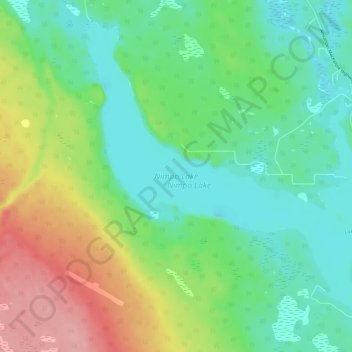
Name: Topografische Karte Nimpo Lake, Höhe, Relief.
Durchschnittliche Höhe: 1.150 m
Minimale Höhe: 1.112 m
Maximale Höhe: 1.225 m
Spenden
Rüste dich für dein nächstes Abenteuer:
Als Amazon-Partner verdient diese Website an qualifizierten Käufen, ohne zusätzliche Kosten für Sie.
Andere topografische Karten
Klicken Sie auf eine Karte, um ihre Topografie, ihre Höhe und ihr Relief anzuzeigen.
Anahim Lake
Canada > British Columbia > Cariboo Regional District > Area J (West Chilcotin)
Durchschnittliche Höhe: 1.101 m
Mount Juno
Canada > British Columbia > Cariboo Regional District > Area J (West Chilcotin)
Durchschnittliche Höhe: 2.219 m
Kondor Lake
Canada > British Columbia > Cariboo Regional District > Area J (West Chilcotin)
Durchschnittliche Höhe: 1.718 m
Heckman Pass
Canada > British Columbia > Cariboo Regional District > Area J (West Chilcotin)
Durchschnittliche Höhe: 1.519 m
Spenden
Rüste dich für dein nächstes Abenteuer:
Als Amazon-Partner verdient diese Website an qualifizierten Käufen, ohne zusätzliche Kosten für Sie.
Itcha Range
Canada > British Columbia > Cariboo Regional District > Area J (West Chilcotin)
Durchschnittliche Höhe: 1.747 m
Ilgachuz Range
Canada > British Columbia > Cariboo Regional District > Area J (West Chilcotin)
The Ilgachuz Range is a name given to an extinct shield volcano in British Columbia, Canada. It is not a mountain range in the normal sense, because it was formed as a single volcano that has been eroded for the past five million years. It lies on the Chilcotin Plateau, located some 350 kilometres (220 mi)…
Durchschnittliche Höhe: 2.018 m
Rainbow Range
Canada > British Columbia > Cariboo Regional District > Area J (West Chilcotin)
Durchschnittliche Höhe: 1.741 m
Nimpo Lake
Canada > British Columbia > Cariboo Regional District > Area J (West Chilcotin)
Durchschnittliche Höhe: 1.131 m
Spenden
Rüste dich für dein nächstes Abenteuer:
Als Amazon-Partner verdient diese Website an qualifizierten Käufen, ohne zusätzliche Kosten für Sie.
Anahim Peak
Canada > British Columbia > Cariboo Regional District > Area J (West Chilcotin)
Durchschnittliche Höhe: 1.416 m
Puntzi Mountain
Canada > British Columbia > Cariboo Regional District > Area J (West Chilcotin)
Durchschnittliche Höhe: 1.293 m
The Joker
Canada > British Columbia > Cariboo Regional District > Area J (West Chilcotin)
Durchschnittliche Höhe: 2.157 m
Great Canyon
Canada > British Columbia > Cariboo Regional District > Area J (West Chilcotin)
Durchschnittliche Höhe: 1.220 m
Spenden
Rüste dich für dein nächstes Abenteuer:
Als Amazon-Partner verdient diese Website an qualifizierten Käufen, ohne zusätzliche Kosten für Sie.
Great Canyon
Canada > British Columbia > Cariboo Regional District > Area J (West Chilcotin)
Durchschnittliche Höhe: 1.220 m
Map Glacier
Canada > British Columbia > Cariboo Regional District > Area J (West Chilcotin)
Durchschnittliche Höhe: 2.037 m