Geolokalisieren

Topografische Karte Provinz Luanda

Interaktive Karte

Klicken Sie auf die Karte, um die Höhe anzuzeigen.

Über diese Karte

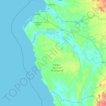
Name: Topografische Karte Provinz Luanda, Höhe, Relief.

Ort: Provinz Luanda, Angola (-10.45624 12.78978 -8.58002 14.62167)

Durchschnittliche Höhe: 86 m

Minimale Höhe: -2 m

Maximale Höhe: 1.170 m

Andere topografische Karten

Klicken Sie auf eine Karte, um ihre Topografie, ihre Höhe und ihr Relief anzuzeigen.

Londuimbali

Angola > Provinz Huambo

Durchschnittliche Höhe: 1.571 m

Cambambe

Angola > Provinz Cuanza Norte

Durchschnittliche Höhe: 153 m

Huíla

Angola > Provinz Huíla

Durchschnittliche Höhe: 1.168 m

Cuando

Angola > Provinz Huíla > Caconda

Durchschnittliche Höhe: 1.579 m

Chongolo

Angola > Provinz Cuanza Sul > Chongolo

Durchschnittliche Höhe: 1.310 m

Quinguenguere

Angola > Provinz Cuanza Sul > Quinguenguere

Durchschnittliche Höhe: 943 m

Quitundo

Angola > Provinz Cuanza Sul > Quitundo

Durchschnittliche Höhe: 1.445 m