
Topografische Karte Cantal
Interaktive Karte
Klicken Sie auf die Karte, um die Höhe anzuzeigen.
Über diese Karte
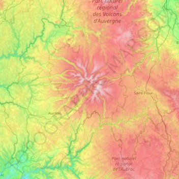
Name: Topografische Karte Cantal, Höhe, Relief.
Ort: Cantal, Auvergne-Rhône-Alpes, Metropolitan France, France (44.61593 2.06290 45.48356 3.37129)
Durchschnittliche Höhe: 825 m
Minimale Höhe: 183 m
Maximale Höhe: 1.810 m
Cantal lies in the middle of France's central plateau. The Cantal range is a group of extinct and eroded volcanic peaks. Its highest point is the Plomb du Cantal, which reaches an elevation of 1,858 meters (6,096 ft). Its neighbors are Puy Mary (elev. 1,787 meters or 5,863 feet) and Puy Chavaroche (elev. 5,722 feet or 1,744 meters). To their north lie the Cézallier and Dore ranges and the arid Artense Plateau. Immediately to their east is the fertile Planèze Plateau, bound on its east by the Monts de la Margeride.
Andere topografische Karten
Klicken Sie auf eine Karte, um ihre Topografie, ihre Höhe und ihr Relief anzuzeigen.
Allanche
France > Auvergne-Rhône-Alpes > Cantal
Allanche, Saint-Flour, Cantal, Auvergne-Rhône-Alpes, Metropolitan France, 15160, France
Durchschnittliche Höhe: 1.117 m