
Topografische Karte Blanca Peak
Interaktive Karte
Klicken Sie auf die Karte, um die Höhe anzuzeigen.
Über diese Karte
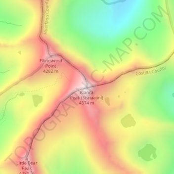
Name: Topografische Karte Blanca Peak, Höhe, Relief.
Ort: Blanca Peak, Alamosa County, Colorado, United States (37.57756 -105.48558 37.57766 -105.48548)
Durchschnittliche Höhe: 3.871 m
Minimale Höhe: 3.347 m
Maximale Höhe: 4.363 m
Blanca Peak is notable not only for its absolute height, but also for its great local relief and dominant position at the end of the range, rising high above the San Luis Valley to the west. For example, it rises nearly 7,000 feet (2,100 m) over the edge of the San Luis Valley in only 6 miles (9.7 km). Blanca is also the third most topographically prominent peak in Colorado; it is separated from the higher peaks in the Sawatch Range by relatively low Poncha Pass at 9,019 feet (2,749 m).
Andere topografische Karten
Klicken Sie auf eine Karte, um ihre Topografie, ihre Höhe und ihr Relief anzuzeigen.
Lake Como
United States > Colorado > Alamosa County
Lake Como, Alamosa County, Colorado, United States
Durchschnittliche Höhe: 3.718 m