
Topografische Karte Island County
Interaktive Karte
Klicken Sie auf die Karte, um die Höhe anzuzeigen.
Über diese Karte
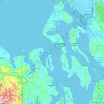
Name: Topografische Karte Island County, Höhe, Relief.
Ort: Island County, Washington, United States of America (47.81745 -122.98899 48.41564 -122.32846)
Durchschnittliche Höhe: 98 m
Minimale Höhe: -3 m
Maximale Höhe: 2.084 m
Andere topografische Karten
Klicken Sie auf eine Karte, um ihre Topografie, ihre Höhe und ihr Relief anzuzeigen.
Olympic National Park
United States of America > Washington
Olympic National Park, Washington, United States of America
Durchschnittliche Höhe: 412 m
Skykomish
United States of America > Washington > Skykomish
Skykomish, King County, Washington, United States of America
Durchschnittliche Höhe: 441 m
Clallam County
United States of America > Washington
Clallam County, Washington, United States of America
Durchschnittliche Höhe: 335 m